|
||

|

|
|

|
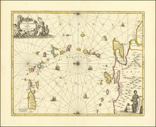
Extremely rare separately published map of the Virgin Islands, from contemporary English Surveys.
This very rare, separately-issued chart of the Virgin Islands is the most interesting and important for the area of the 18 th century. It is the earliest specifically of the islands listed in the catalogues of the Library of Congress (Phillips) and the British Museum, and served as a prototype for many later maps and charts.
Published by the firm of Mount & Page, it never appeared in their well-known The English Pilot Book Four. It was instead published separately, and must have been included in some copies of their composite atlas, the Atlas Maritimus, of which no two copies appear to be identical. We have been unable to locate any example that contains this chart. Loose copies can be found in the Library of Congress and the British Library. One in the latter institution is notes as being from the "Admiral Lord Howe Collection."
The chart's title notes that it was largely adapted by "C. Mortimer" from an original manuscript prepared by Joseph Atkinson, of Spanish Town, Virgin Islands, for Gilbert Fleming, Lieutenant-General of the British Leeward Islands (1733-52). Cornwall Mortimer, Physician and associate of Sir Hans Sloane, was elected to the Royal Society in 1728, and mainly through the interest of Sloane was acting secretary of the Society from Nov. 1730 until his death. He was the author of many works on medicine and science. Through Sloane, he was a confidant of the naturalist Mark Catesby, and with the latter co-authored "A Continuation of an Account of an Essay Towards a Natural History of Carolina and the Bahamas" in 1746.
The fine ornamentation is suggestive of the work of Catesby, and includes a shell, aquatic plants, a tropic bird, and a flying fish. At upper-right is a decorative cartouche containing a dedication by Mortimer to Sir Charles Wager, First Lord of the Admiralty (1733-1742), and member of the Privy Council. Wager was Commander-in-Chief of Jamaica in 1707, when he engaged in his most famous exploit: the defeat and destruction at Cartagena of part of the Spanish treasure fleet.
Mortimer shows all of the Caribbean from the eastern end of Porto Rico to St. Kitts, including St. Martin's and St. Bart's. The title notes that the area of St. Croix ("Santa Cruz") and St Kitts ("St. Christopher") were taken from some source other than Atkinson's manuscript. The configuration for St. Croix is quite crude, indicating that the English had little knowledge of this island, then in Danish hands. Tables in the upper-left and lower-right corners contain information on the various islands.
Among the later mapmakers who used Mortimer's chart as a source were Bellin (1764), and Thomas Jefferys (1775), for his chart of The Virgin Islands, included in his West India Atlas. Jefferys follows Mortimer in showing the 1595 route of Sir Francis Drake through the islands, "Sir Francis Drake's Bay", and the "King's Channel". The shape and place names for many islands are similar or identical.

![West Indies. Corrected to 1846 [Bermuda Inset]](https://storage.googleapis.com/raremaps/img/small/94053.jpg)