|
||

|

|
|

|
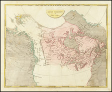
Rare map of the West Coast of North America, from Cape St Elias to San Blas on the Mexican mainland, centered on San Francisco (which has not yet been discovered).
The map apparently was issued to illustrate a German scientific journal, likely illustrating the results of Cook's contact with the West Coast (Cook's Harbor 1778 is the latest date on the map) or something contemporary to this date, as Vancouver and La Perouse's discoveries are not in evidence.
The map is noteworthy in several respects. The annotations include reference to Fousang, the Chinese explorer who reportedly made contact with the West Coast of North America long before Columbus' voyages. Tchirikow's contacts with the region are also noted, as is Drake's landfall in 1578. The annotations also referene the Spanish contact with the region. However, despite the references to these early contacts (some of which are quite dubious in nature), the treatment of the coastline is quite scientific and avoids much of the myth and legend of contemporary maps.
The map is apparently quite rare, this being the first example we have ever seen.
![[Part of Orange County] Anaheim Quadrangle](https://storage.googleapis.com/raremaps/img/small/83489.jpg)
![[Unique Extra-Illustrated Example!] Carte Nouvelle Contenant La Partie d'Amerique La Plus Septentrionale, . . . Le Canada ou Nouvelle France, La Nouvelle Ecosse, La Nouvelle Angleterre, Les Nouveau Pais Bas, La Pensylvanie . . . Et Jle. de Terre Neuve . . .](https://storage.googleapis.com/raremaps/img/small/47720.jpg)