


|
||

|

|
|

|
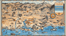
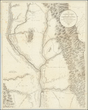
Important Gold Rush era map by Lt. George H. Derby (Phoenixiana), perhaps the earliest scientific work on the Gold rush. The map is extremely detailed (1" = 4.5 miles), covering the region from 10 miles south of Sacramento to the Oroville area and from modern day Colusa to Colluma (Coloma). Excellent detail on the local roads, including the Benicia, Shadon's Ranch, Daylor's Rancho, Vernon and other early roads, including the Lawson's Route-Emigrant's Road. Rose's Rancho, Rose's Bar, Cordua's Bar and "Diggers" are located on the Yuba River. Mormon Isla, Karnakas Diggings and Dry Diggings are shown on the American River. Many other place names and fascinating features. Wheat describes the map as being of major importance. Wheat (Gold Region) 149.