


|
||

|

|
|

|
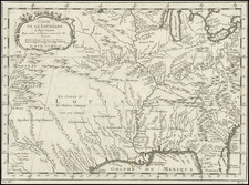
Extremely rare map of the mouth of the Red River and Cut Off, near the mouth of the Mississippi, illustrating the State of Louisiana's efforts to reverse the effects of an early environmental disaster caused by the Army Corps of Engineers' efforts to re-direct the Rivers to improve navigation and commerce on the rivers.
The present map was prepared by the State Engineer, George T. Dunbar, at some point during the State of Louisiana's efforts to reverse the catastrophic effects of the Army Corps' ill-conceived channel. As noted by Carl A. Brasseaux and Keith P. Fontenot in Steamboats on Louisiana's Bayous: A History and Directory (page 63-65)
The Red River route proved highly problematic to the steamboat industry, primarily because of wildly fluctuating water levels in the upper and lower Old River. The upper and lower Old River branches were originally part of Turnbull Bend, an enormous westward oxbow of the Mississippi River; the Red River intersected the upper part of the bend, and the efflux of Atchafalaya River was located about three miles downstream. In 1831, the U.S. Corps of Engineers Office of Western River Improvement, then under the direction of civilian steamboat pioneer Henry Miller Shreve, dug a cutoff across the bend's narrow neck in the hope that it "would not only eliminate river mileage [for steamers on the trunk routes], but increase the current enough to eliminate the silting at the mouth of the Red River. Instead, the cutoff, which quickly captured the Mississippi's main channel, became a major environmental disaster . . . Within thirty-five years of the cutoff's completion, Lower Old River was completely dammed by accumulated driftwood. Water flow through the Atchafalaya was reduced substantially; in the long low-water season it was limited to waters diverted from the Red River. Because these diverted waters constituted a small percentage of the Red River's flow, the Atchafalaya River shrank in the 1830s. Indeed, during the 1839 drought, a person "could walk across the Atachafalaya on a 15-foot plank."
The resulting navigational problems elicited a public outcry . . . During the 1830s, Congress funded a wide variety of comparable navigational improvement projects . . . but the national depression of 1837 ushered in a new era of extreme fiscal conservatism. Congress consequently refused to consider any new internal improvements projects in Louisiana . . . The state government was consequently compelled to act alone, and no official action was taken until the end of the decade. Undoubtedly driven by frustration with government inertia, several Atchafalaya Valley residents set fire to the rafts, resulting in innumerable roasted alligators but no appreciable improvement in the stream's navigability.
In 1839, the state government directed the state engineer, George T. Dunbar, to assign snag boats to remove the Atchafalaya raft. After two years of intensive work, Dunbar reported that a narrow channel had been opened. Until rafting temporarily closed the Atchafalaya River to navigation in 1846, Teche steamers navigated the stream between June and December, when Bayou Plaquiemine was not navigable. . . .
Dunbar's map is of the utmost rarity. We have been completely unable to locate any example of the map, although we do note a document entitled Report of a majority of the Committee on the subject of the Raccourci Cut-off. in the Library of Louisiana State University, which is described as "Report of the State Engineer, in relation to the obstructions at the mouth of Red River (p. 23-30) : New Orleans, 1843. Report of the minority of the Committee on Internal Improvements (p. 30-37)," although no map is mentioned.
In the Mississippi River Commission Historical Map Catalog (on-line database) there is an entry entitled "Mouth of Red River," and dated 1805-1905, which states "These charts accompanied a MRC report to Congress on the separation of the Red and Atchafalaya Rivers from the Mississippi River." The maps are credited to "C. W. Clark, B. M. Lafon, G. T. Dunbar, Louis Herbert, G. M. Derby, J. F. McIndoe." The reference is 894-SH.5. The size given (30 x 13.75 inches) does not match the present map.
We have located a second reference in the same source, which may be related, a set of maps listed as "Development of Old River and Turnbull Island, La." and credited to B. Lafon and George T. Dunbar, which includes an entry dated (1805-1960) and references "These four copies show the evolution and development of the Old River and Turnbull Island in Louisiana. Also includes 12 copies of a similar map." (894-Sh.142).
George T. Dunbar served as State Engineer for the state of Louisiana for a number of years in the 1830s and 1840s. Among other noteworthy facts, in abut 1835, Dunbar proposed an ambitious system of underground drainage canals beneath the streets of New Orleans. The goal was to drain water by gravity into the low lying swamps, supplementing this with canals and mechanical pumps. The first of the city's steam engine powered drainage pumps, adapted from a ship's paddle wheel and used to push water along the Orleans Canal out to Bayou St. John, was constructed in this decade. However, only a few of Dunbar's plans were actually implemented as the Panic of 1837 largely ended major systematic improvements for a generation.
![[Jefferson's Notes on the State of Virginia] Observations sur la Virginie [with the map:] A Map of the country between Albemarle Sound, and Lake Erie, comprehending the whole of Virginia, Maryland, Delaware, and Pensylvania, with parts of several other of the United States of America. Engraved for the Notes on Virginia.](https://storage.googleapis.com/raremaps/img/small/51828.jpg)
![[Battle of Yorktown] Plan D'York en Virginie avec les attaques et les Campemens de l'Armee combinee de France et d'Amerique](https://storage.googleapis.com/raremaps/img/small/102603.jpg)

![[Rare First State] Novissima Tabula Regionis Ludovicianae Gallice dictae la Louisiane . . .](https://storage.googleapis.com/raremaps/img/small/72622.jpg)