This item has been sold, but you can enter your email address to be notified if another example becomes available.


|
||

|

|
|

|
Stock# 15480
Description
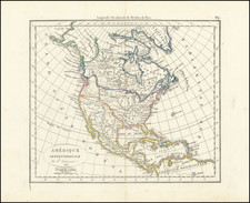
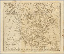
Interesting early map of North America, pre-dating the discoveries of Lewis & Clark. The Rocky Mountains are a single Cordillera, from Canada to the Gila River. The Missouri extends speculatively into the Snake Nation. Louisiana Territory dominates the mid-continent. East and West Florida are shown, as is Texas (an early appearance as a placename). Pimeria, Apacheria, Nabaho and several western tribes appear, as do tribes in the Mississippi Valley. The treatment of the NW Coast post-dates Vancouver. The reports of MacKenzie and Hearne have interesting treatment, with a note naming the Dog Ribb'd Indians. Primitive NW Coast. A nice early map, immediately prior to the departure of Lewis & Clark.
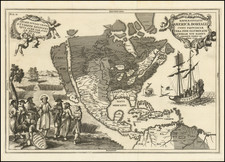
![A New Mapp of America Septentrionale . . . 1669 [California shown as an island]](https://storage.googleapis.com/raremaps/img/small/94304.jpg)