|
||

|

|
|

|
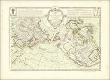
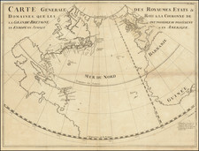
Rare sea chart of the North Atlantic by Theodore De Bry, based upon Hessel Gerritsz' extremely rare map of 1612. The map was prepared to illustrate the track of the fourth and final voyage of Henry Hudson in his hunt for a Northwest Passage. Hudson had previously made 3 voyages of discovery, the first two in 1607 and 1608 for the English Muscovy Company in search of a Northeast Passage and the last for the Dutch East India Company in 1609, which led to the discovery of the Hudson River. Hudson set sail on his final voyage in April 1610, ultimately discovering Hudson Bay, before heading south along the eastern shore and before wintering at the southernmost point of James Bay. After a bitter winter, the ice broke and freed the ship in June 1611. A few days later, after his crew mutinied, Hudson was set adrift and was never seen again. There were only eight people from the crew who made it back to England in September of 1611. One of these men, Abacuck Prickett, apparently returned with the manuscript version of this map, which made its way to Amsterdam in 1612, where Gerritsz published the map along with his account of the voyage and issued again the following year by De Bry in his Petit Voyages. Copies of the Gerritsz edition of the map are extremely rare. The map records Hudson's belief that he had found the Pacific Ocean with the Mare Magnum named at far left, later named Hudson Bay. What would become James Bay is shown erroneously with two large bays of its own. A landmark map in the exploration of the North Sea and the Arctic. Adorned with a trio of beautiful compass roses, rhumb lines, a decorative cartouche and the royal crest of Britain. Burden 165; Kershaw 55.
Theodor de Bry (1528-1598) was a prominent Flemish engraver and publisher best known for his engravings of the New World. Born in Liege, de Bry hailed from the portion of Flanders then controlled by Spain. The de Brys were a family of jewelers and engravers, and young Theodor was trained in those artisanal trades.
As a Lutheran, however, his life and livelihood were threatened when the Spanish Inquisition cracked down on non-Catholics. De Bry was banished and his goods seized in 1570. He fled to Strasbourg, where he studied under the Huguenot engraver Etienne Delaune. He also traveled to Antwerp, London, and Frankfurt, where he settled with his family.
In 1590, de Bry began to publish his Les Grands Voyages, which would eventually stretch to thirty volumes released by de Bry and his two sons. The volumes contained not only important engraved images of the New World, the first many had seen of the geographic novelties, but also several important maps. He also published a collection focused on India Orientalis. Les Grands Voyages was published in German, Latin, French, and English, extending de Bry’s fame and his view of the New World.