


|
||

|

|
|

|
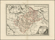
Rare early edition of Blaeu's map of Brabant, oriented with west at the top of the map. On the lower left a magnificent cartouche with a sitting female figure carrying a globe and compasses and the coat of arms of Brabant. On the left, a second female sits atop the cartouche and next to the coat of arms. The map includes the area between the rivers Rhine, Meuse and Scheldt, with Namur as the most southern town. From the 1634 edition of Blaeu's Atlas Novus, the first edition of this work. A fine dark impression. The map first appeared in Blaeu's rare 1631 Atlas Appendix. This is the second appearance of the map in Blaeu's atlas. A fine dark impression, with wide margins and attractive color.
Willem Janszoon Blaeu (1571-1638) was a prominent Dutch geographer and publisher. Born the son of a herring merchant, Blaeu chose not fish but mathematics and astronomy for his focus. He studied with the famous Danish astronomer Tycho Brahe, with whom he honed his instrument and globe making skills. Blaeu set up shop in Amsterdam, where he sold instruments and globes, published maps, and edited the works of intellectuals like Descartes and Hugo Grotius. In 1635, he released his atlas, Theatrum Orbis Terrarum, sive, Atlas novus.
Willem died in 1638. He had two sons, Cornelis (1610-1648) and Joan (1596-1673). Joan trained as a lawyer, but joined his father’s business rather than practice. After his father’s death, the brothers took over their father’s shop and Joan took on his work as hydrographer to the Dutch East India Company. Later in life, Joan would modify and greatly expand his father’s Atlas novus, eventually releasing his masterpiece, the Atlas maior, between 1662 and 1672.
![Europe No. 16. Partie De La Russie D'Europe [Tambow, Woroniege, Saratow and Territoire De La Milice De Don, etc.]](https://storage.googleapis.com/raremaps/img/small/19823.jpg)
![[Untitled Map of Sicily, Sardinia and Naples]](https://storage.googleapis.com/raremaps/img/small/12524.jpg)
![[Europe: Air Mail Routes] Carte des lignes postales aeriennes internes et internationales Europe pubilee par le Bureau International de l'Union postale universelle Berne, Avril 1937](https://storage.googleapis.com/raremaps/img/small/41144.jpg)