|
||

|

|
|

|
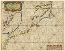
Scarce map of the West Indies, comprising the upper left sheet of Blaeu's 4 sheet West Indische Pascaert, issued in 1630. There are only 2 known examples of the complete 4 sheet map.
In 1634, Blaeu was in the process of releasing his newest Atlas, aptly titled Atlas Novus. In Blaeu's haste to release the atlas, he was apparently unable to complete the Hessel Geritsz map of the Caribbean which bears the same title as this map, so instead, Blaeu elected to include the upper left sheet of his West Indische Pascaert, masking over portions of the printed borders and adding a paste down title in the upper left corner.
The inclusion of the map is a milestone in North American cartographic history, as it represents the first map to focus on the a portion of North America to utilize Mercator's Projection. Blaeu's map of the Atlantic is one of the few contemporary maps to depict the Dutch colonial activities in the New World. It is surmised that the West Indische Pascaert was never offered for general sale to the public, because it lacks a priviledge, making this the first generally available example of the map.
The map also represents a remarkable step forward in the mapping of the areas around New York and the Chespeake, which Blaeu had substantially re-worked from earlier maps and charts. The New England Coastline follows the work of Blaeu's 68 cm globe of 1617. Burden notes that the existence of this map was not re-discovered until 1927. Tony Campbell located a second example in 1984. By the time of Burden's writing, he noted that a total of 7 examples of the map were known in public collections. The present example is one of those located by Burden.
Willem Janszoon Blaeu (1571-1638) was a prominent Dutch geographer and publisher. Born the son of a herring merchant, Blaeu chose not fish but mathematics and astronomy for his focus. He studied with the famous Danish astronomer Tycho Brahe, with whom he honed his instrument and globe making skills. Blaeu set up shop in Amsterdam, where he sold instruments and globes, published maps, and edited the works of intellectuals like Descartes and Hugo Grotius. In 1635, he released his atlas, Theatrum Orbis Terrarum, sive, Atlas novus.
Willem died in 1638. He had two sons, Cornelis (1610-1648) and Joan (1596-1673). Joan trained as a lawyer, but joined his father’s business rather than practice. After his father’s death, the brothers took over their father’s shop and Joan took on his work as hydrographer to the Dutch East India Company. Later in life, Joan would modify and greatly expand his father’s Atlas novus, eventually releasing his masterpiece, the Atlas maior, between 1662 and 1672.