|
||

|

|
|

|
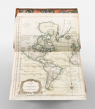
Derivative of De L'Isle's landmark map of the region. Excellent up to date map of Texas, Florida and the Gulf Coast, a region then only recently opened to non-Spanish Flag ships. The map also provides marvelous detail of the regions drained by the Mississippi, drawing upon the early French exploration of the region at the end of the 17th Century, which was just beginning to find its way into printed maps. The Apalachicoli River, leading to Caskigi is one of the more more interesting features in the South. Excellent treatment of the Indians and villages and early French settlements in the interior of North America. A striking example, with very minor repairs along the inner neatline, otherwise near fine condition.
Henri Abraham Chatelain (1684-1743) was a Huguenot pastor of Parisian origins. Chatelain proved a successful businessman, creating lucrative networks in London, The Hague, and then Amsterdam. He is most well known for the Atlas Historique, published in seven volumes between 1705 and 1720. This encyclopedic work was devoted to the history and genealogy of the continents, discussing such topics as geography, cosmography, topography, heraldry, and ethnography. Published thanks to a partnership between Henri, his father, Zacharie, and his younger brother, also Zacharie, the text was contributed to by Nicolas Gueudeville, a French geographer. The maps were by Henri, largely after the work of Guillaume Delisle, and they offered the general reader a window into the emerging world of the eighteenth century.
![[Early Texas Aeronautical Navigation Map] Aeronautical Map For Cross Country . . Drawn by Cpl. V.G. Smylie Aero Squadron, Ellington Field](https://storage.googleapis.com/raremaps/img/small/59678.jpg)