|
||

|

|
|

|
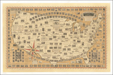
Terrific large format map illustrating the territories in the Western US, published by the Geographisches Institut in Weimar. Washington & Oregon Territories extend to the Rockies. Utah and New Mexico extend from California to east of the Rockies. Kansas Territory extends from the Rockies to the Missouri River. Nebraska Territory extends to Canada. Dakota Territory is formed, but not in its present configuration. Texas is oversized, following the Red River. California is misconfigured. The map names many Indian Tribes and early forts in the west. Many of the early overland routes and explorers routes are shown. Many mountain ranges, capes, keys, points, ports, bays, lakes, Islands, rivers, creeks, and other landmarks are shown. The cartography north of the 49th parallel in the west is highly detailed. One of the most interesting maps of the period.
![Vereinigte Staaten Von Nordamerika [United States of North America]](https://storage.googleapis.com/raremaps/img/small/92015.jpg)