This item has been sold, but you can enter your email address to be notified if another example becomes available.


|
||

|

|
|

|
Stock# 13224
Description
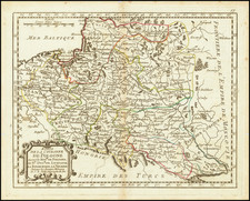
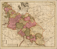
Detailed map of Poland, which is shown including the Baltic States, Galicia and Prussia. A note and colored boundaries reflect the Congress of Vienna and Identify the Russian, Prussian, and Austrian Dominions, along with the Territory of the Free Town of Cracow. Shows towns, roads, rivers, lakes, mountains, islands, roads, etc. From Smith's General Atlas. Nice topographical detail.