|
||

|

|
|

|
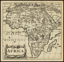
Scarce map of Asia and Africa, illustrating the great English explorer John Davis' route from England to the East Indies in 1597. While perhaps better known for his two voyages of exploration in search of the Northwest Passage (1585 and 1587). Davis did not return to the Arctic, but he did reach Asia. He got there for the first time in 1598 as a pilot with one of the expeditions conducted for large commercial companies. In 1600, he became chief pilot for the first expedition of the East India Company. On his three voyages to the Indies, he drew geographical maps and records information that was important for navigating in the Orient. On 27 December 1605, off the coast of Malaysia, Davis was assassinated by one of the Japanese pirates whose ship he had just captured. This map was originally used by Vander Aa to illustrate his travel narrative of this expedition. The map illustrated an early account of the New World published by Vander Aa, one of the most prolific compilers of information on the early explorations to America, Asia and Africa. A finely executed copper plate engraving with decorative cartouche.
Pieter van der Aa (1659-1733) was a Dutch mapmaker and publisher who printed pirated editions of foreign bestsellers and illustrated books, but is best known for his voluminous output of maps and atlases. Van der Aa was born to a German stonecutter from Holstein. Interestingly, all three van der Aa sons came to be involved in the printing business. Hildebrand was a copper engraver and Boudewyn was a printer.