|
||

|

|
|

|
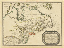
Important early map of the Midwest, issued in the rare pocket edition of Finley's New American Atlas. Michigan is still a territory, with only 10 counties shown and only a small group of towns, the rest of the land being Miamis and Ottowas Territory. Illinois includes a number of massive northern counties, which stretch from the southern part of the state to nearly its northern border (Fayette, Edgar and Clark County), ending at the Sauks and Foxes Indian Boundary. Edgar County bends to the right, to include Chicago and Ft. Dearborn). Indiana is dominated in the North by two oversized regions, one being the Pottowatamie Indian lands and the other Kickapoo lands, with Allen County being the first formed in the North. The Northwest Territory is still shown, including a massive undefined Craford County, with the rest of the land shown being delineated for the Winnebagos. The map also extends into Missouri and Missouri Territory, including the lands of the Sioux and Ioway Indians. A number of early roads are shown, as are some early township surveys in Michigan Territory. Statistical Table includes information on size, population, historical populations and Capitals. A very nice example, which has been flattened, de-acidified and archivally backed. A few minor spots, but generally an excellent example of the map, which is rarely found in such nice condition.
Anthony Finley (1784-1836) was an American map publisher. Little is known about his life. He is presumed to have been born in Philadelphia, where he also died. A publisher, Finley was also involved in several Philadelphia civic and professional societies such as the Philadelphia Apprentices’ Library. He may have been in business as early as 1809 and his first publication dates from ca. 1811.
His first maps also date from this year, with two maps in Daniel Edward Clarke’s Travels in Various Countries of Europe, Asia, and Africa. The first atlas published by Finley appeared in 1818, the Atlas classica, or, Select maps of ancient geography, both sacred and profane, for the use of colleges and schools in the United States. He is best known for his A New General Atlas Comprising a Complete Set of Maps (1824), which was a bestseller. There were two editions in 1824, with annual editions until 1834.
Finley was part of the first generation of American publishers who produced high quality, precise maps on American soil. He was in competition with other Philadelphia publishers, for example Henry S. Tanner. Finley’s A New American Atlas Designed Principally to Illustrate the Geography of the United States of America (1826) closely mirrors Tanner’s A New American Atlas Containing Maps of the Several States of the North American Union, with similar groupings of maps; the main difference is the smaller scale of Finley’s maps. Finley printed two editions of this atlas.
![[Eastern Sheet -- Ohio] Post Road Map of the States of Ohio and Indiana with Adjacent Parts of Pennsylvania Michigan Illinois Kentucky and West Virginia Showing Post Offices With The Intermediate Distances and Mail Routes In Operation On the !st of February 1885 . . .](https://storage.googleapis.com/raremaps/img/small/44153.jpg)