|
||

|

|
|

|
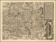
This mid-18th century map, created by the renowned cartographer Johann Baptist Homann, provides a detailed depiction of the western part of the Franconian Circle (Circulus Franconiae), including the entire Electorate of Mainz (Electoratum Moguntinum). The map is notable for its meticulous detail, vibrant hand coloring, and the elaborate allegorical cartouche that enhances its artistic and historical value.
The map illustrates the western region of Franconia, a significant administrative division within the Holy Roman Empire. The hand-colored boundaries delineate various territories within the region, highlighting the geopolitical landscape of the time. Major cities, towns, rivers, and roads are intricately detailed, offering a comprehensive view of the area's geography and infrastructure, including Frankfurt, Darmstat, Mainz, Heidelberg, Stuttgart, Heilbron, Wertheim, and Coblenz.
The lower left section of the map features an elaborate allegorical cartouche, a hallmark of Homann's cartographic works. The cartouche is adorned with numerous symbolic elements and figures, adding depth and context to the map's presentation. The cartouche prominently displays portraits of two significant ecclesiastical leaders: the Archbishop of Mainz, Johann Philipp von Schönborn (1605-1673), and his successor, Lothar Franz von Schönborn (1656-1729). These figures are flanked by angels and allegorical figures representing virtues and ecclesiastical authority.
Surrounding the portraits are various allegorical elements, including cherubs, trumpets, and symbols of justice and wisdom. These elements underscore the religious and judicial significance of the Electorate of Mainz within the Holy Roman Empire. The cartouche includes a Latin inscription that extols the virtues and accomplishments of the depicted ecclesiastical leaders. It serves both as a dedication and a historical testament to their influence and governance. The cartouche is further embellished with classical motifs, such as drapery, columns, and laurel wreaths, enhancing its visual appeal and reinforcing the map's grandeur.
The map reflects the intricate political and territorial divisions of the Holy Roman Empire in the mid-18th century. The Electorate of Mainz, one of the most important ecclesiastical principalities within the empire, is depicted with particular emphasis.
Johann Baptist Homann (1663-1724) was a mapmaker who founded the famous Homann Heirs publishing company. He lived his entire life in Bavaria, particularly in Nuremberg. Initially, Johann trained to become a priest before converting to Protestantism and working as a notary.
In 1702, Johann founded a publishing house that specialized in engravings. The firm flourished, becoming the leading map publisher in Germany and an important entity in the European map market. In 1715, Johann was named Imperial Geographer to the Holy Roman Empire by Charles VI and made a member of the Prussian Academy of Sciences. Most importantly for his business, his reputation and contacts gained him imperial printing privileges which protected his publications and recommended him to customers. Johann is best known for this Grosser Atlas ueber die ganze Welt, or the Grand Atlas of the World, published in 1716.
After Johann died in 1724, the business passed to his son, Christoph (1703-1730). Upon Christoph’s early death, the company passed to subsequent heirs, with the name of the company changing to Homann Erben, or Homann Heirs. The firm continued in business until 1848.
![[Napoleon's Battles in France, Belgium Netherlands, Luxembourg, Germany] No. 1 Frontiere du Nord. Mesny 5.](https://storage.googleapis.com/raremaps/img/small/60727.jpg)
![(First state!) [ Upper Rhine River Valley -- Strasbourg to Basle ] Alsatia et Brisgoia II Rheni Et VII Nova Tabula](https://storage.googleapis.com/raremaps/img/small/94641.jpg)