


|
||

|

|
|

|
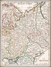
This early 18th-century two-sheet map, titled Mappae Imperii Moscovitici pars Septentrionalis and Mappae Imperii Moscovitici pars Australis, offers a comprehensive depiction of the northern and southern parts of the Russian Empire, also known as the Moscovite Empire. Based upon the work of the distinguished French Royal cartographer Guillaume de l'Isle and published by Matthäus Seutter in Augsburg, the map intricately details the vast and varied territories of the Russian Empire, extending from the Baltic Sea in the west to the Ural Mountains in the east, and from the Arctic Ocean in the north to the Caspian Sea and the borders of Central Asia in the south.
The northern sheet, pars Septentrionalis, covers the northern territories, including the White Sea (Mare Album), the northern part of European Russia, and parts of Siberia. Major subregions include Ingria, Karelia, and the area around Lake Ladoga and Lake Onega. The map highlights key rivers such as the Northern Dvina and the Pechora, along with numerous smaller lakes and river systems that were crucial for transportation and trade.
The southern sheet, pars Australis, encompasses the southern territories, including parts of Ukraine, the Volga River basin, and the steppe regions extending towards the Caspian Sea. Significant subregions depicted include the Duchies of Ryazan, Vladimir, and Moscow, as well as the Don Cossack territories and the Crimean Khanate. Major cities such as Moscow, Kiev, and Astrakhan are prominently marked, reflecting their importance as administrative and commercial centers.
During the first half of the 18th century, the Russian Empire underwent significant expansion and modernization under the reign of Peter the Great and his successors. Peter's reforms aimed to transform Russia into a major European power, both militarily and culturally. The Great Northern War (1700-1721) against Sweden, which culminated in the Treaty of Nystad, significantly altered the political landscape, granting Russia access to the Baltic Sea and establishing it as a dominant regional power. The map reflects these changes, showcasing the expanding borders and the incorporation of new territories into the empire.
The allegorical cartouche in the close-up is an elaborate and decorative element that adds to the map's artistic value. It features a heraldic shield supported by two bears, symbolizing strength and resilience, and is adorned with various motifs such as a hunter with a bow, horse, additional bears and scrollwork. The cartouche is topped with a crown, indicating the imperial authority of the Russian tsars. The inscription credits Guillaume de l'Isle as the cartographer and Matthäus Seutter as the publisher, highlighting the collaboration between these two prominent figures in the cartographic world.
Matthäus Seutter (1678-1757) was a prominent German mapmaker in the mid-eighteenth century. Initially apprenticed to a brewer, he trained as an engraver under Johann Baptist Homann in Nuremburg before setting up shop in his native Augsburg. In 1727 he was granted the title Imperial Geographer. His most famous work is Atlas Novus Sive Tabulae Geographicae, published in two volumes ca. 1730, although the majority of his maps are based on earlier work by other cartographers like the Homanns, Delisles, and de Fer.
Alternative spellings: Matthias Seutter, Mathaus Seutter, Matthaeus Seutter, Mattheus Seutter
![[ Crimea ] Spezial Karte von dem Konigreich Taurien oder del Halbinsel Krim](https://storage.googleapis.com/raremaps/img/small/101372.jpg)
![[Napoleon]. A Sketch of the Russian Campaign in 1812](https://storage.googleapis.com/raremaps/img/small/63426.jpg)
![[ Earliest Obtainable Map of Russia, Ukraine, and the Caucauses ] Secunda Asiae Tabula](https://storage.googleapis.com/raremaps/img/small/82673.jpg)
![[ Kaliningrad / Poland / Lithuania ] Des Konigreichs Preussen nordostlicher Theil](https://storage.googleapis.com/raremaps/img/small/101749.jpg)