|
||

|

|
|

|
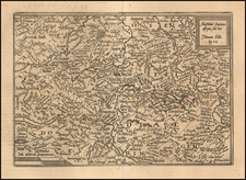
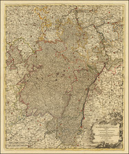
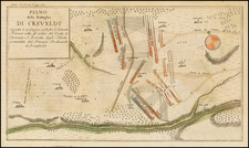
This early 18th-century map, created by renowned cartographer Johann Baptist Homann, presents a detailed depiction of the Archdiocese and Electorate of Cologne, including the Duchies of Jülich and Berg, as well as the County of Meurs. The title is ornately illustrated with allegorical figures and coats of arms, symbolizing the various regions represented.
The map features several coats of arms prominently displayed in the title cartouche. The central shield depicts the cross of Cologne, flanked by the lion rampant of Jülich and the red lion of Berg. These heraldic symbols reflect the historical territories under the ecclesiastical and secular authority of the Elector of Cologne, who was one of the seven prince-electors of the Holy Roman Empire.
During the early 18th century, the region depicted in this map was a significant ecclesiastical and political entity within the Holy Roman Empire. The Electorate of Cologne, established as an archbishopric in the early Middle Ages, held substantial influence both spiritually and politically. The Elector-Archbishop of Cologne was a key figure in the imperial electoral process, responsible for selecting the Holy Roman Emperor.
The Duchies of Jülich and Berg were important territories in the Rhineland, strategically located along key trade routes and rivers. The County of Meurs, though smaller, played a vital role in the region's complex feudal structure.
The map shows numerous towns and rivers, integral to understanding the geography and settlement patterns of the time. Key towns include Cologne (Colonia), Aachen (Aix-la-Chapelle), and Düsseldorf, which were centers of commerce, culture, and political administration. The rivers Rhine (Rhenus) and Ruhr (Ruhrus) are prominently featured, highlighting their importance as transportation and trade routes.
The Rhine River, flowing through Cologne, was particularly crucial for trade and movement within the Holy Roman Empire, connecting the region to the North Sea and beyond. The intricate network of smaller rivers and tributaries depicted on the map underscores the region's rich agricultural and economic landscape.
Johann Baptist Homann (1663-1724) was a mapmaker who founded the famous Homann Heirs publishing company. He lived his entire life in Bavaria, particularly in Nuremberg. Initially, Johann trained to become a priest before converting to Protestantism and working as a notary.
In 1702, Johann founded a publishing house that specialized in engravings. The firm flourished, becoming the leading map publisher in Germany and an important entity in the European map market. In 1715, Johann was named Imperial Geographer to the Holy Roman Empire by Charles VI and made a member of the Prussian Academy of Sciences. Most importantly for his business, his reputation and contacts gained him imperial printing privileges which protected his publications and recommended him to customers. Johann is best known for this Grosser Atlas ueber die ganze Welt, or the Grand Atlas of the World, published in 1716.
After Johann died in 1724, the business passed to his son, Christoph (1703-1730). Upon Christoph’s early death, the company passed to subsequent heirs, with the name of the company changing to Homann Erben, or Homann Heirs. The firm continued in business until 1848.