|
||

|

|
|

|
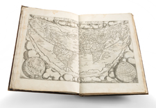
Unknown second edition, published with a new title and without the illustrated text. With a large woodcut title-border, 25 engraved charts (all but one double-page). The nautical atlas is "A translation of Pieter Goos's pilot guide of the Mediterranean, first published in 1662. The plates have been copied from the 25 charts in Goos's Straets-Boeck" (Koeman). "Levanto's chart (of Cyprus) was reproduced by Coronelli, through whose publications it became widely known" (Navari).
Bibliographically untraceable. The maps were revised by Levanto and first published in 1664 under the title Prima parte dello specchio del mare, nel quale si descrivono tutti li porti, spiaggie, baye, isole, scogli e seccagni del Mediterraneo. The atlas includes 2 maps of Cyprus, including the Carta maritima dell'isola Cypri dismostrante le meridionali coste with an inset map of the Egyptian coast between Alexandria and Damietta at the bottom (Stylianou 144).
The picturesque large title border here corresponds entirely to that of the 1664 edition. The present second edition probably appeared without the text illustrated with coastal profiles and harbor plans.
![[ World Atlas ] A New Sett of Maps Both Antient and Present Geography . . . Together with A Geographical Treatise Particularly Adapted to the Use and Design of these Maps . . .](https://storage.googleapis.com/raremaps/img/small/69332.jpg)
![Atlas Nouveau, Contenant Toutes Les Parties du Monde, Ou sont exactement Remarquees les Empires, Monarchies, Royaumes, Etats, Republiques &c. [New Atlas, Containing All the Parts of the World, Where Exactly Remarked are the Empires, Monarchies, Kingdom, States, Republics, &c.]](https://storage.googleapis.com/raremaps/img/small/71061.jpg)