


|
||

|

|
|

|
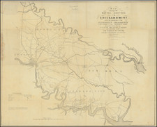
Siege of Atlanta
Scarce battle plan of the Siege of Atlanta, published in 1866.
The map shows the actions of the Union and Rebel forces between Sherman's arrival outside of Atlanta on July 19, 1864, and his movement on the enemy line's south of Atlanta on August 26, 1864.
The map is based upon an original manuscript map prepared by Captain O.M. Pope of the Army Corps of Engineers. The map is widely regarded as the first obtainable map of the area to include a street plan of Atlanta.
Extends from Buckhead, Howell's Mill and Casey Montgomery Church in the north to Decatur and Peach Tree Church in the East Point, and Terry's Mill in the south and Utoy Post Office and Mt. Gileud Church in the west, centered on Atlanta. Extensive notes, topographical details, roads, rivers, and many other place names and landowners names shown.
Perhaps somewhat confusingly, the Union lines are in red, and the Confederate are in blue.

![[Port Lucie/Indian River to Cape Hatteras] East Coast of North America from the U.S. Coast Survey and the most recent authorities. Sheet V. . . . 1870](https://storage.googleapis.com/raremaps/img/small/90697.jpg)
![[ Vicksburg Battle Plan ] Map Illustrating The Operations of the U.S. Forces Against Vicksburg.](https://storage.googleapis.com/raremaps/img/small/60302.jpg)
![Neueste Karte von Georgia mit seinen Strassen, Eisenbahnen und Entfernungen 1845. [Latest Map of Georgia with its Roads, Railways, and Distances 1845.]](https://storage.googleapis.com/raremaps/img/small/94441.jpg)