|
||

|

|
|

|
A Remarkable Compilation
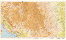
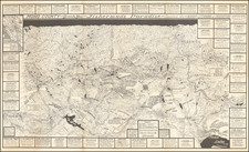
Rare large map of California, lithographed by Britton and Rey and sold by Hooper & Berner of San Francisco.
The map provides an exceptional overview of California in the last decade of the 19th Century. The General Land Office Township surveys are virtually completed, except for the most remote parts of Eastern Riverside County, San Bernardino County, Inyou County, Mono County and Fresno County. Imperial County is not established.
Many of the smaller Indian Reservations are shown in Southern California.
Areas of Gold Mining appear in some unusual places, such as north of La Crescenta and Glendora in the foothills of the San Gabriel Mountains, east of Menifee and Laguna in Riverside County (Pinacate District, likely the Good Hope Mine) and the area north of Funeral Mountains in Inyo County, as well as the usual places in Gold Country. An area of Fresno County, north of Coalinga, is labeled "Petrolum Claims," likely relating to the 1890 discoveries of the Coast Range Oil Company of Los Angeles.
Relief shown by hachures and spot heights. Shows drainage, counties, railroads (completed and proposed), roads, Indian reservations, township and range lines, etc. Extensive index in upper right.
Rarity
OCLC locates only 3 examples, two 1894 and one 1895 edition.