|
||

|

|
|

|
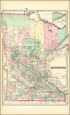
Scarce separately issued example of this important early map of Minnesota Territory, including all of Dakota, issued by Charles Desilver (with his new decorative border style).
The map is based largely on the works of Nicollet and Pope and includes extensive notes on early exploration and topography throughout.
Includes some interesting county configurations, as a number of counties are named west and southwest of Lake Superior, but the exact configurations are still very much in flux.
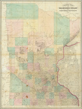
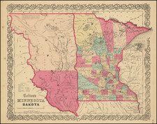
An essential map for Minnesota and Dakota collectors. One of the earliest editions of the map, first issued in 1850, the year after Minnesota became a territory. Massive Pembina and Dacotah counties in the west, with many Indian Tribes, forts and early exploration notes shown.