|
||

|

|
|

|
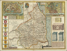
This exquisite map of Middlesex, titled Middle-Sexia, was created by the renowned Dutch cartographer Willem Janszoon Blaeu in the mid-17th century. Blaeu's maps are celebrated for their accuracy, artistic quality, and intricate details, and this map is a quintessential example of his craftsmanship.
The map depicts Middlesex, an historic county in southeast England, bordered by the counties of Hertfordshire, Essex, Buckinghamshire, and Surrey, and embracing the city of London along the River Thames, which ceased to exist after April 1, 1965. The cartography of Middlesex is finely detailed, showing the various "Hundreds" (administrative divisions) such as Elthorne, Gore, Edmonton, and Spelthorne. Each hundred is meticulously outlined and populated with settlements, manors, forests, and rivers. The map also highlights notable locations including Enfield Chase, Waltham Forest, Watford, Uxbridge, Great Brentford, High Bernet (Barnet) and areas around London, illustrating the region's geographical and administrative layout during the period.
One of the most striking features of this map is its decorative elements. In the upper left corner, Blaeu has placed an elaborate coat of arms, symbolizing the county's heraldic heritage. The lower right corner is adorned with a grand cartouche, flanked by allegorical figures and surrounded by lush foliage and flowers.
Willem Janszoon Blaeu (1571-1638) was a prominent Dutch geographer and publisher. Born the son of a herring merchant, Blaeu chose not fish but mathematics and astronomy for his focus. He studied with the famous Danish astronomer Tycho Brahe, with whom he honed his instrument and globe making skills. Blaeu set up shop in Amsterdam, where he sold instruments and globes, published maps, and edited the works of intellectuals like Descartes and Hugo Grotius. In 1635, he released his atlas, Theatrum Orbis Terrarum, sive, Atlas novus.
Willem died in 1638. He had two sons, Cornelis (1610-1648) and Joan (1596-1673). Joan trained as a lawyer, but joined his father’s business rather than practice. After his father’s death, the brothers took over their father’s shop and Joan took on his work as hydrographer to the Dutch East India Company. Later in life, Joan would modify and greatly expand his father’s Atlas novus, eventually releasing his masterpiece, the Atlas maior, between 1662 and 1672.
![[ Atlas of England & Wales ] Geographiae Blauianae Volumen Quintum, quo Anglia, quae est Europae liber undecimus, continentur](https://storage.googleapis.com/raremaps/img/small/99196.jpg)