|
||

|

|
|

|
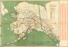
This map, titled The Alaska Line: When You Think Alaska - Think Alaska Steamship Co., illustrates the extensive network of routes operated by the Alaska Steamship Company, a significant entity in the development and operation of transportation in Alaska during the early 20th century. This map not only showcases the primary maritime routes but also highlights key land routes, particularly the Copper River & Northwestern Railway and the Alaska Railroad, integral to the infrastructure of the region.
The inset map provides a detailed view of the Copper River & Northwestern Railway and the Alaska Railroad, focusing on the copper-rich regions of Alaska, Prince William Sound, and the Richardson Automobile Highway. It includes important natural landmarks such as Mt. McKinley National Park and various coal fields, telegraph lines, and stage routes. This close-up offers a clearer understanding of the railroads' paths, key stations, and the areas they serve.
Constructed primarily to facilitate the transport of copper ore from the rich mines of Kennecott, the Copper River & Northwestern Railway extends from the coastal town of Cordova through the rugged Alaskan interior. Notable for its engineering challenges and scenic routes, this railway played a critical role in the economic development of the region. Spanning from Seward to Fairbanks, the Alaska Railroad was crucial for the settlement and development of Alaska. It provided a vital link between the coastal ports and the interior regions, facilitating the movement of goods, resources, and people across vast distances. The inclusion of the Matanuska and Nenana coal fields on this map underscores the economic importance of these railroads in tapping into Alaska's natural resources.
The development of these transportation networks during the early 20th century was a testament to the ambitions of the time, aiming to unlock Alaska's vast natural wealth. The Copper River & Northwestern Railway, completed in 1911, was instrumental in supporting the Kennecott Copper Corporation, one of the world's largest and most productive copper mines of its era. The Alaska Railroad, completed in 1923, further bolstered economic growth by connecting the resource-rich interior with coastal ports, thus integrating Alaska more fully into the national economy.
The Alaska Steamship Company, which commissioned this map, was pivotal in the region's maritime history, offering comprehensive passenger and freight services that connected Alaskan communities with the broader world. This map not only served as a practical guide for travelers and shippers but also as a promotional tool, underscoring the company's commitment to linking Alaska's remote and rugged landscape to global markets and transportation networks. The map highlights various economically significant regions in red, including the Nome, Fairbanks, and Klondike gold regions, numerous oil and coal fields, several salmon districts, and the U.S. Seal Reserve.
![Charte von Nord-America Prag 1818 [Rare Alaska Inset Map]](https://storage.googleapis.com/raremaps/img/small/72184.jpg)