|
||

|

|
|

|
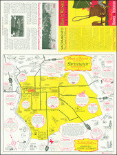
Dwight Way Realty Company Promotional Map -- Berkeley, California, 1904
The Map of Berkeley created by City Engineer C. L. Huggins and corrected to January 1, 1904, is a valuable historical document that offers a detailed representation of the street layout and real estate development in early 20th century Berkeley. The map meticulously delineates the city's streets, avenues, and significant landmarks, reflecting the urban planning and expansion of Berkeley at a time of considerable growth.
This promotional map was designed to highlight the offerings of the Dwight Way Realty Company, located at the north-west corner of Dwight Way and Shattuck Avenue, as prominently indicated by the red pointer on the map. The company's address, 2444 Shattuck, is clearly marked, underscoring its central role in the burgeoning real estate market of the area.
Historically, the early 1900s were a period of rapid development in Berkeley, spurred by the establishment and expansion of the University of California, Berkeley.
The reverse side of the map includes an elaborate cover page that lists the directors of the Dwight Way Realty Company: J. L. Barker (President), F. S. Page (Vice-President), Frederick H. Clark, S. D. Ayres, J. L. Barker, Frederic P. Barker, and F. S. Page. This inclusion of corporate leadership provides insights into the individuals driving the real estate growth in Berkeley at the time.
![[San Francisco Earthquake and Fire] Destruction of San Francisco By Earthquake and Fire, April 18th 1906 / Every Building Shown In the Above Picture Was Destroyed by the Great Fire](https://storage.googleapis.com/raremaps/img/small/88832.jpg)