|
||

|

|
|

|
Homesteading In California After World War I
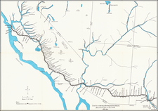
This map, produced by the Department of the Interior, shows areas in California designated for homesteading under the provisions of the Enlarged Homestead Acts as of June 1919. The map highlights in red the lands available for settlement, reflecting the ongoing implementation of homestead policies that were crucial in the development and expansion of agricultural and rural communities in California during the early 20th century.
The Homestead Act of 1862, signed into law by President Abraham Lincoln, was a significant piece of legislation aimed at promoting the settlement and development of the American West. The original act allowed any American, including freed slaves, to put in a claim for up to 160 acres of federal land, provided they improved the land by building a dwelling and cultivating crops. This act was a cornerstone of westward expansion, encouraging millions of Americans to migrate west in search of new opportunities.
By the early 20th century, additional versions of the Homestead Act were enacted to address various challenges and expand the opportunities for settlement. The Enlarged Homestead Act of 1909 increased the amount of land available to settlers to 320 acres, recognizing the need for larger tracts of land to sustain agricultural operations in the more arid regions of the West. The Stock-Raising Homestead Act of 1916 further expanded opportunities by allowing settlers to claim 640 acres of land primarily for livestock grazing, acknowledging the different agricultural needs of the western territories.
After World War I, there was a renewed surge of interest in homesteading as returning soldiers and their families sought to establish stable, self-sufficient lives. The promise of land ownership attracted many, contributing to a wave of migration into California. This influx helped to populate rural areas, promoting the growth of small farming communities and contributing to the demographic diversity of the state. The migration was not limited to veterans; many individuals from other states also moved westward, drawn by the opportunities that California's vast and varied landscapes offered.
In California, the application of these homestead acts had a profound impact, particularly in the central and southern parts of the state. The map indicates (in red) that significant areas of available land were concentrated in regions such as the Central Valley, the foothills of the Sierra Nevada, and parts of the Southern California Desert regions. These areas were targeted for their agricultural potential and suitability for homesteading, offering settlers the chance to cultivate crops and raise livestock.
Southern California saw extensive homesteading activity, with notable regions including the high desert areas around Joshua Tree. This area, known for its distinctive Joshua Trees, became an attractive site for settlers seeking to establish ranches and small farms in the arid landscape. The availability of large tracts of land under the homestead acts facilitated the development of communities that would later contribute to the region's unique character and agricultural output.
In the Sierra Nevada, communities emerged around areas such as the western foothills and the eastern slopes. The land here, although rugged, offered fertile valleys and water sources vital for agriculture and livestock. Homesteading in these regions led to the establishment of small towns and agricultural hubs that played a crucial role in the local economy. The Sierra Nevada's diverse landscapes, ranging from dense forests to open meadows, provided a range of opportunities for settlers willing to adapt to the challenging environment.
The regions highlighted on the map in red reflect the primary areas impacted by the homestead acts in California. These lands, designated by the Secretary of the Interior, were critical in transforming vast stretches of undeveloped territory into productive farmland and rural communities. The map’s legend includes symbols for U.S. Surveyor Generals Offices, U.S. Land Offices, county boundaries, townships not subdivided, and U.S. Lighthouses, providing additional context for understanding the geographic and administrative framework within which homesteading took place.
The map is an exemplary piece of early 20th-century cartography, offering valuable insights into the land distribution policies that shaped California’s development. For collectors and historians, it serves as a significant artifact that illustrates the ongoing legacy of the Homestead Act and its role in the settlement and agricultural expansion of California. The detailed depiction of available homestead lands and the associated administrative infrastructure provide a comprehensive overview of the state's land use policies during a pivotal period in its history.
![Mexico [Texas on the Eve of Independence]](https://storage.googleapis.com/raremaps/img/small/84917.jpg)