


|
||

|

|
|

|
Stock# 103694
Description
Rare Full Original Publisher's Color
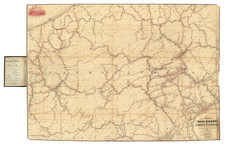
Exceptional old color example of Mathew Carey's map of Pennsylvania, one of the best large format maps of the state to appear in a commercial atlas.
The map is attractively hand-colored by counties, showing towns, roads, mountains, rivers, lakes, and a host of other early important details.
This first appeared in Carey's General Atlas, which was published in 1814. This was the first American Atlas to be offered for sale with outline hand coloring on the maps. This is the second full original color example we have seen (1992-2024).
Condition Description
Engraving on 19th-century laid paper. Original hand-coloring. Minor offsetting. Very minor foxing.
![A New and Exact Map of the Dominions of the King of Great Britain on ye Continent of North America . . . [Beaver map]](https://storage.googleapis.com/raremaps/img/small/101277.jpg)
![(Three Days at Gettysburg) Map of the Battlefield of Gettysburg July 1st, 2nd, 3rd 1863. . . [Three Maps]](https://storage.googleapis.com/raremaps/img/small/101769.jpg)
![[Pennsylvania] A New and accurate Map of the Province of Pennsylvania in North America from the best Authorities](https://storage.googleapis.com/raremaps/img/small/77862.jpg)