|
||

|

|
|

|
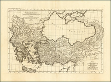
Detailed map of Cyprus, Asia Minor and contiguous Islands and the Black Sea region, from Paola Santini's large atlas, published in Venice.
The map includes a note showing that the distance from Crimea, across the Black Sea, is 170 miles at the nearst point.
The map delineates the geopolitical and topographical contours of the region known in antiquity as Anatolia, situated at the confluence of continents, cultures, and epochs.
The 18th century was a period of significant transition for Asia Minor, predominantly under the control of the declining Ottoman Empire. This map, therefore, not only serves as a geographical record but also as a silent testament to the ebb of Ottoman influence amidst rising European intervention. The delineation of boundaries within the map reflects both the ancient partitions of the region into provinces such as Cappadocia, Bithynia, and Pontus, as well as the Ottoman administrative divisions. The inclusion of Cyprus, a nexus of Mediterranean trade and strategic military interest, hints at its complex history of rule, which, by the date of this map's creation, had seen Venetian and Ottoman dominion.
The engraving captures a rich topography of mountain ranges such as the Taurus and the Zagros, vital river systems including the Meander and Halys, and the rugged coastline with its significant harbors. Colored lines possibly denote the routes of ancient roads, pilgrimage trails, or territorial demarcations, indicative of the region's role as a crossroads of various civilizations. The cartouche, a work of art in its own right, embellishes the title with an aesthetic typical of the period, potentially designed to appeal to the map's affluent European clientele, who valued such objects for their scholarly and aesthetic appeal.
Paolo Santini (1729-1793) was an Venetian engraver known especially for his religious prints and fine cartographic engravings. He published in Venice and may have a been a member of the clergy. In his maps, he largely adopted and adapted the work of his French counterparts, especially the brothers de Vaugondy.

![(Ancient Turkey and Middle East) Tabula Itineris Decies Mille Graecorum Cyro merentium contra fratrem Artaxerxem Regem Persarum [The Retreat of the Ten Thousand Greeks]](https://storage.googleapis.com/raremaps/img/small/89459.jpg)
![A New Map of the Eastern Parts of Asia Minor Largely taken as Also of Syria, Armenia, Mesopotamia &c . . .Dedicated to his Highness William Duke of Glocester [shows Cyprus]](https://storage.googleapis.com/raremaps/img/small/90579.jpg)