|
||

|

|
|

|
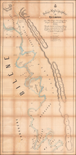
Henry Hall's First Printed Map -- One of The Most Important Early Maps of South Africa Under British Rule
Rare early map of Eastern part of South Africa, based upon the surveys of Henry Hall.
Henry Hall (biography below) was active in South Africa in the 1840s and early 1850s, primarily as an engineer in the Eastern Frontier. The Eastern Frontier
zone played an important role in South African history as it constituted the primary contact zone between whites and blacks in the 19th Century.
Hall's map was profoundly impactful in advancing the cartographic knowledge of South Africa. As noted by Liebenberg:
Disregarding the maps of Arrowsmith and Wyld, [Hall] painstakingly built his own cartographical database and in 1852 wrote to the Governor of the Cape Colony that he was almost ready to provide the country “with what hitherto has been so much required: a tolerably correct Map of South Africa”. His printed maps of 1856, 1857 and 1859 were cases in point and in 1857 Her Majesty’s Astronomer at the Cape, Sir Thomas Maclear, referred to Hall’s printed map of South Africa as “beyond question, far in advance of any previous attempt”.
In 1849, Hall compiled a manuscript map of the Eastern Frontier of South Africa, spotlighting the districts of Albany, Victoria, Somerset, Fort Beaufort, and portions of Colesberg, Cradock, and Graaff-Reinet. His mapping effort merged historical surveys, primarily carried out by Royal Engineers under Captain Holloway between 1819 and 1824, with personal observations, including those from the 1840s under Captain W.F.D. Jervois, R.E. Hall's maps also incorporated corrections from existing sketches housed in the Royal Engineers’ bureau in Grahamstown and his own field surveys in British Kaffraria between the Keiskamma and Kei Rivers conducted by Captain Jervois in 1847-48.
Further north, the Albert district was charted using resources from J.C. Chase, Reverend William Shaw, and government surveyor C. Bird, thereby extending Hall's geographic scope to include the northern Kei River, Stormberg Spruit, Kraai River, upper Orange River, and Witteberg Mountains. Contributions from W. Shepstone, Esq., and W. Orpen, Esq., enhanced the map of Victoria, while Colesberg benefited from the integrative efforts of Fleetwood Rawstorne, who synthesized farm diagrams to craft a comprehensive map released in London in 1842.
The maps also received updates and refinements from figures such as Arrowsmith and Wyld in Graaff-Reinet, Richmond, and the Winterveld, with William Southey contributing to these revisions. The Great Karroo and Beaufort areas saw additions from H. Marriott’s sketches. Notably, Dr. Guybon Atherstone, a respected medical practitioner, naturalist, and geologist from Grahamstown, enriched the maps of Uitenhage and Somerset, particularly in the geological sections, highlighting the collaborative nature of this cartographic endeavor.
This collective of geographical data, diligently gathered and refined by Hall and his associates, reflects the evolving understanding of South Africa’s terrain during a crucial period of its colonial history. These maps function not only as tools for navigation but also as historical documents, capturing the convergence of scientific surveying, personal observation, and local expertise in the mid-19th century. Hall dedicated these maps of the Eastern Frontier of the Cape Colony to the British Inspector-General of Fortifications, Sir John Burgoyne, further underscoring their significance.
During his 1852-53 leave in London, Hall, likely carrying his 1850 manuscript map, was ordered back to Cape Town by special request and favor of the Inspector-General, in large part to continue his mapping work. His comprehensive knowledge of the Eastern Frontier suggests that his work would surpass the contemporary accuracy of Arrowsmith's 1847 map, which was updated following significant regional changes including those from the Eighth Frontier War. Hall’s map of the Eastern Frontier, similar in scale but more detailed than Arrowsmith’s, included distinctions such as permanent and temporary military posts, and demarcated boundaries absent on the Arrowsmith map, thus providing a richer, more informative depiction of the region.
In 1856 Stanford’s Geographical Establishment in London published Henry Hall’s comprehensive Map of the Eastern Frontier of the Colony of the Cape Good Hope, the first of several printed maps which would distinguish Hall in the annals of printed maps of South Africa. Compiled from local authoritative information only, this map not only surpassed its predecessors in scale and completeness, but also achieved a marked degree of accuracy.
Mapping South Africa
The present map is the first map of the Easetern Frontiers of South Africa, published 1 year prior to Hall's monumental map of South Africa, the first map entirely produced in the Colonies
In discussing the publication history of Hall's 185 map of South Africa, Elri LIebenberg notes:
In 1857, [Henry] Hall became the first resident cartographer to publish a map of the entire African region south of 16°S. Entitled South Africa, this map was the first of its kind ever to be produced in South Africa as not only the compilation, but also the engraving, printing, colouring and mounting were undertaken locally. In 1859 Stanford’s published two additional maps, under Hall’s name: one of the subcontinent south of 25° 30’S entitled South Africa, and another entitled Map of South Eastern Africa from Algoa to Delagoa Bay.
In spite of Henry Hall’s rightful claim to fame as South Africa’s foremost pioneer cartographer, little has been published on his cartographical work. . .
As noted by Liebenberg:
What makes Hall’s map [of South Africa] of 1857 of particular interest is that it is one of the earliest cartographical documents of southern Africa to include not only the newly found[ed] Boer republics of the Orange Free State (founded 1854) and the Transvaal (founded 1852), but also the routes followed by the mid-19th century explorers ) Orpen and Shelley (1852), Chapman (1854), Livingstone (1853 and 1856), C.J. Andersson (1853), Moffat and Edwards (1854), and Green and ahlberg (1856) during their explorations into the vast area north of 20° South. By including these routes on his map Hall extended the northern limit of his manuscript maps of 1849 and 1850 with 10° and therewith consciously moved into the unknown parts of southcentral Africa. Hall was a personal friend of almost all the above-mentioned explorers and a possible explanation for his bold decision is that he considered it his duty and obligation to make their geographical achievements known to the wider public.
* * *
Hall’s representation of the Orange Free State and Transvaal Republics comprised only the second printed map of these newly founded states, the first being a map by Hermann Berghaus published in the German periodical Petermanns Geographisches Mitteilungen of 1855. Equally interesting is the fact that Hall’s map is the first printed map on which the name “Pretoria”, the capital of the Republic and founded in 1855, appear. . .
* * *
Soon after its publication in South Africa Hall sold the copyright of his map of 1857 to Stanford of London who used the existing plates to publish the complete map under both an English and a Dutch title. However, in 1859 Stanford transferred the area south of 25° S to a conical projection, re-engraved it and published another edition, slightly updated . . . Except for the area between 16° S and 26° S which was discarded, all detail on the original 1857 map was retained. Although the actual reason for doing away with the area north of 25 S is not clear, especially as the map border now cuts through the Transvaal, the decision was probably based on the scanty information that was available on these areas.
Rarity
The present map is rare on the market.
Edward Stanford (1827-1904) was a prominent British mapmaker and publisher. A native of Holborn in the heart of London, Edward was apprenticed to a printer and stationer at the age of 14. After his first master died, he worked with several others, including Trelawny W. Saunders of Charing Cross. Saunders oversaw young Edward’s early career, ensuring that he became a Fellow of the Royal Geographical Society. Associations with the Society eventually brought Sanders much business and gave him a reputation as a publisher of explorers. As testament to this reputation, the Stanford Range in British Columbia was named for him by John Palliser.
Stanford briefly partnered with Saunders in 1852 before striking out on his own in 1853. He was an agent for the Ordnance Survey, the Admiralty, the Geological Survey, the Trigonometrical Survey of India, and the India Office. He also controlled the maps of the Society for the Diffusion of Useful Knowledge, another lucrative source of income. In 1857, Stanford founded his namesake Geographical Establishment, with Saunders and A. K. Johnston as engravers. Thereafter, Stanford was known for his “library maps”, particularly those of Africa and Asia.
Addresses and Years of Operation:
- 6 Charing Cross, London (1848): Edward Stanford's initial place of employment at Trelawney Saunders' shop.
- 7 and 8 Charing Cross, London (1853): Stanford expanded his shop to these addresses.
- 55 Charing Cross, London (1873): The shop moved to this larger location.
- 12-14 Long Acre, London (1873): Site of the new print works and current flagship store.
- 7 Mercer Walk, London (2019): Stanfords moved to this address, continuing its legacy.
Stanford's work with Chief Cartographer John Bolton, including the 1858 Library Map of Europe, positioned the company as a leader in quality cartography during a time of exploration and colonialism. Their 1862 Library Map of London earned acclaim from the Royal Geographical Society. With the business thriving, Stanford purchased Staunton & Son in 1877 and, upon retiring in 1885, handed over the reins to his son, Edward Stanford II.
As sole agents for Ordnance Survey Maps, the company's influence and reputation grew, culminating in the Stanford’s London Atlas Of Universal Geography, which was presented to Queen Victoria in 1887. The transition into the 20th century saw further integration of retail, print, and cartographic operations at Long Acre.
During World War I, Stanford's became an essential publisher for the War Office. Edward Fraser Stanford took over in 1917, steering the company through the interwar period and innovations, such as the world’s smallest maps in 1922 and the Daily Mail Motor Road Map in 1926.
Withstanding a bombing in WWII, the company continued under the stewardship of John Keith Stanford and was sold to George Philip & Son in 1947. As it adapted to the digital age, Stanfords received the Ordnance Survey Premier Partner status in 2007 and ventured into online mapping and data services.
Stanfords, now an icon for travellers and explorers, has maintained its cultural relevance and retail success well into the 21st century, underpinned by a legacy of entrepreneurial spirit and commitment to cartographic excellence.
The following is excerpted from Eli Lienbenberg's paper on Henry Hall and his maps.
In 1828, the death of his father compelled him to seek work in order to support his financially embarrassed family.
In 1839, after having worked for a builders firm for nine years, Hall entered the Government Service as Foreman of Works in the Royal Engineer Department. His appointment was greatly promoted by the fact that he gained first place in a competitive examination with eighteen other candidates, and in 1842 he was ordered to the Cape Colony.
Hall served on the Eastern Frontier during the Frontier Wars of 1846 and 1851-52, first in Grahamstown and later in Fort Beaufort before moving back to Grahamstown. In 1852, Hll returned to England for health reasons where he was employed in the Office of the Inspector-General of Fortifications until he returned to Cape Town in 1853 at his own request.
In 1858 he was promoted to the rank of Clerk of Works of the first class after which his designation was “Clerk in charge of Royal Engineer Department”. In 1860, he was requested to finally return to England as the Cape was not considered a station for officers of his class.
During his stay in South Africa Hall contributed richly to the scientific and cultural life of the mid-nineteenth century Cape. As engineer he was actively involved in the erection of fortifications on the Eastern Frontier and in later years he supervised the building of several public buildings in Cape Town, amongst which the current South African Museum and National Library.
He was also a competent and avid writer who regularly contributed publications and translations of either a scientific or literary nature to the Eastern Province Monthly Magazine and the Cape Monthly Magazine. In June 1860, prior to his final departure from Cape Town, the Cape Parliament voted him a testimonial of £100 in recognition of his services to
public life in general.
Attached to the Portsmouth Royal Engineer Office for some time, he moved to London after his retirement where he died in 1882.
![South Africa [Map Your Holiday in South Africa]](https://storage.googleapis.com/raremaps/img/small/96622.jpg)
![(South Africa) Coutumes Moeurs & Habillemens des Peuples Qui Habitent aux Environs du Cap de Bonne Esperance avec une Description des Animaux et Reptiles qui set truvent dans ce Pais [Customs, Manners, and Attire of the Peoples Who Inhabit the Vicinity of the Cape of Good Hope, with a Description of the Animals and Reptiles Found in this Country.]](https://storage.googleapis.com/raremaps/img/small/89738.jpg)