|
||

|

|
|

|
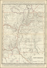
The Largest Obtainable New Mexico Territory Map Published In the 19th Century
This map, issued by the General Land Office in 1896, offers a comprehensive view of the Territory of New Mexico during a pivotal era of westward expansion and land management in the United States.
The legend details the map's key features, which include:
- Surveyor General's Office and U.S. Land Offices: Locations of administrative offices managing land affairs.
- Military Reservations: Areas designated for military use, often encompassing forts and training grounds.
- Indian Reservations: Lands reserved for Native American tribes under various treaties.
- Forest Reservations: Designated forest areas, now known as National Forests, set aside for conservation.
- Confirmed Private Grants: Privately claimed lands that have been recognized by the government.
- Unconfirmed Private Claims: Claims to land by private individuals or entities not yet ratified by the government.
- Claims Needing New Boundary Lines: Confirmed private land claims that require updated demarcation.
- Rejected or Dismissed Claims: Private claims to land that have been invalidated or dismissed.
- Townships Subdivided: Areas that have been surveyed and divided into townships.
The map delineates county boundaries, towns, cities, and the routes of railroad lines, which were vital to the development and settlement patterns of the time. Relief is indicated by hachures, which are lines used to depict elevation on maps.
Historically, the Territory of New Mexico underwent several transformations before becoming a state. Originally part of the Spanish empire, the region passed to Mexico in 1821 after the Mexican War of Independence. It later became a U.S. territory following the 1848 Treaty of Guadalupe Hidalgo, which ended the Mexican-American War. The United States acquired additional land under the 1853 Gadsden Purchase. Over the subsequent decades, the territory saw several shifts in boundaries and governance before achieving statehood in 1912. Throughout this period, land rights, especially those pertaining to Native American reservations and private land claims, were significant and contentious issues, as illustrated by the detailed classifications in the map's legend.
The General Land Office (GLO) refers to the independent agency in the United States that was in charge of public domain lands. Created in 1812, it assumed the responsibilities for public domain lands from the United States Department of the Treasury. The Treasury had overseen the survey of the Northwest Territory, but as more area was added to the United States, a new agency was necessary to survey the new lands.
Eventually, the GLO would be responsible for the surveying, platting, and sale of the majority of the land west of the Mississippi, with the exception of Texas. When the Secretary of the Interior was created in 1849, the GLO was placed under its authority. Until the creation of the Forest Service in 1905, the GLO also managed forest lands that had been removed from public domain. In additional to managing the fees and sales of land, the GLO produced maps and plans of the areas and plots they surveyed. In 1946, the GLO merged with the United States Grazing Service to become the Bureau of Land Management.