|
||

|

|
|

|
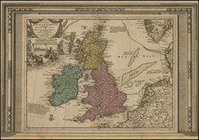
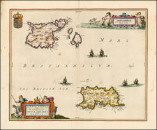
Interesting historical map of the British Isles, which includes "Albion" or "Britannia Major" (Great Britain) and "Ivernia" or "Britannia Minor" (Ireland), as per the geographical understanding of Claudius Ptolemy, the Greco-Roman mathematician, astronomer, and geographer.
The outline of the British Isles is shown in a modern format, but the place names and details are show of the British Isles as understood in the second century AD, divided according to Ptolemy's view. This would be prior to many of the changes that occurred with the various invasions and settlements that shaped the British Isles, such as those by the Vikings, Normans, and others. The geographical coverage includes both major islands with their internal divisions that suggest tribal or kingdom boundaries, as they were understood during Ptolemy's era.
Ptolemy's work on geography was influential throughout the Renaissance and into the Enlightenment, as it provided the only substantial ancient account of the world. This map, created in 1778, showcases how Ptolemy's work continued to influence the cartographic representations of the British Isles, even as more modern and accurate surveys would have been available by that time. The map may have been a historical or educational tool, illustrating the ancient and classical perspective on the geography of a region that by the late 18th century was well mapped and understood quite differently.
Paolo Santini (1729-1793) was an Venetian engraver known especially for his religious prints and fine cartographic engravings. He published in Venice and may have a been a member of the clergy. In his maps, he largely adopted and adapted the work of his French counterparts, especially the brothers de Vaugondy.
![[ Pictish Man Holding Severed Head ] Picti icon](https://storage.googleapis.com/raremaps/img/small/99837.jpg)