|
||

|

|
|

|
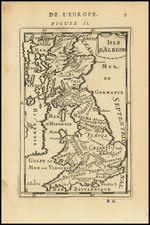
Nice example of William Stuckeley's map of the Roman Roads of Britain, derived from the Antonine Itinerary. This ancient itinerary, a pivotal document of the Roman Empire, provided detailed enumerations of routes, stopping points, and distances, acting as an indispensable resource for understanding the extent and structure of Roman Britain.
The historical context of this map unfolds against the backdrop of the early 18th century, a period marked by a profound interest in antiquarian and archaeological studies, particularly concerning Roman Britain. Stuckeley, an influential figure within this movement, sought to align contemporary British geography with ancient historical texts, contributing significantly to the nascent field of historical geography. His work emerged from a deep engagement with the Antonine Itinerary, which, as a catalog of the Roman Empire's network of roads, furnished essential data for reconstructing the landscape of Roman Britain.
The map itself serves as a meticulous visual representation, plotting the courses and locales documented in the Itinerary against the geographical knowledge of Stuckeley’s time. It symbolizes a bridge between past and present, providing insights into the Roman administrative and military infrastructure through the prism of early modern cartographic practices. By annotating Roman routes, settlements, and landmarks, Stuckeley not only elucidated the Roman road system but also fostered a greater appreciation for Britain’s Roman heritage among his contemporaries.
Antonine Itinerary
The Antonine Itinerary, known in Latin as Itinerarium Antonini Augusti, is a Roman document listing stations and distances along the empire's roads. Believed to be based on official sources, perhaps from a survey under Emperor Augustus, it offers a detailed view of the Roman Empire's road networks, providing a crucial historical insight due to the lack of similar records.
The exact date and authorship of the Itinerary remain unclear, but scholars generally place its origin in the early 3rd century. While traditionally linked to Antoninus Pius, a 2nd-century emperor, the earliest surviving version is attributed to the era of Emperor Diocletian, with Emperor Caracalla being a possible patron.
The section detailing Britain, termed Iter Britanniarum, acts as a Roman road map for the region, consisting of 15 routes covering different areas. It records distances in Roman miles, defined as 1,000 paces (a pace being two steps, left and right, equivalent to 5 Roman feet or about 1.48 meters), which translates to roughly 0.92 miles.