|
||

|

|
|

|
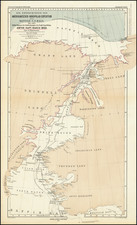
Detailed pictorial road map from circa 1915, depicting the Fort William and Port Arthur districts along with their surrounding areas. This historic map offers a fascinating glimpse into the early 20th-century landscape and infrastructure of this part of Canada, which is known today as part of Thunder Bay, Ontario.
The map is designed with a blend of functionality and artistic elements, typical of the period's cartographic style. The main roads and highways are clearly delineated, connecting the twin cities of Fort William and Port Arthur. These roads extend outwards, illustrating the connections between the two cities and the surrounding regions, including rural areas and smaller communities.
In addition to the roadways, the map highlights significant natural landmarks and geographical features, such as lakes, rivers, and bays. The presence of Lake Superior is prominently noted, along with various smaller bodies of water, indicating the region's rich aquatic landscape. This inclusion would have been particularly useful for transportation and recreational purposes at the time.
The map is filled with pictorial representations and annotations, denoting locations of interest such as fishing areas, where specific types of trout can be found (e.g., speckled trout, lake trout), and other wildlife like deer and moose. These illustrations not only add charm to the map but also provide useful information for tourists and locals engaged in outdoor activities.
Key urban features and infrastructure, such as railways, customs houses, and significant public buildings, are also marked. The cities of Fort William and Port Arthur are depicted with a higher concentration of roads and landmarks, reflecting their status as the central hubs of the district.
At the top and bottom there are numerous local advertisements, with more on the verso.
![National Parks of Canada Jasper Park Alberta North Sheet (Preliminary Edition) [with] National Parks of Canada Jasper Park Alberta South Sheet (Preliminary Edition)](https://storage.googleapis.com/raremaps/img/small/88984.jpg)