|
||

|

|
|

|
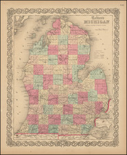
The First Map of Michigan Territory
Nice example of the 1822 edition of Carey & Lea's map of Michigan, the first map of Michigan Territory.
The map illustrates Michigan Territory and the so-called "Indian Line" shortly after the Treaty of Chicago (1821), the third of three treaties with the Native Americans in the region, which would shape the settlement of Michigan Territory for the coming decades.
Virtually no settlements in the interior and the upper peninsula, with most of the towns concentrated on the southeast border. The remainder is Indian Territory, with notes on Portages. Includes Indian Settlements and a few early counties including Monroe, Oakland, DeWayne and Macomb. Early roads are shown and some settlements on Lake St. Claire and Lake Erie, along with Ft Brown and Camp Smith south of Green Bay.
Text around the map describes the Topography, Climate, Animals, Civil Divisions, Population, Towns & Forts, Government, History and remarkable battles fought in Michigan to date.
Indian Line -- Native American Treaties In The Old Northwest & Michigan Territory
The "Indian Line," also known as the Treaty Boundary Line, holds significant historical importance in the context of the Michigan Territory during the 1820s. This demarcation arose from various treaties between the United States government and Native American tribes, particularly in the early 19th century. Its primary purpose was to define territories reserved for Native American tribes and separate them from lands designated for American settlers and governmental use.
The story begins with the Treaty of Greenville in 1795, which followed the Northwest Indian War. This treaty established a boundary line between Native American lands and territories open to American settlers, marking the beginning of a series of land cessions by Native American tribes in the Great Lakes region.
The Treaty of Detroit, signed on November 17, 1807, between the United States and the Odawa (Ottawa), Ojibwe (Chippewa), Wyandot, and Potawatomi nations, resulted in these tribes ceding large portions of land in what is now southeast Michigan and northwest Ohio. The treaty allowed these tribes to retain hunting and fishing rights and set up reservations where they were allowed to live. William Hull, governor of the Michigan Territory, signed the treaty on behalf of the United States. This treaty paved the way for further expansion and settlement by American settlers and the development of infrastructure, including roads and towns, essential for Michigan's eventual statehood.
The Treaty of Saginaw, also known as the Treaty with the Chippewa, was signed on September 24, 1819, between Lewis Cass, territorial governor of Michigan, and chiefs of the Ojibwe, Odawa, and Potawatomi tribes. This treaty resulted in the cession of over six million acres of land in the central portion of the Lower Peninsula of Michigan. The southern boundary of the tract extended from a few miles northeast of Jackson west to just northeast of Kalamazoo. The line then ran directly to the head of the Thunder Bay River in south-central Montmorency County and then along the river to the mouth in Thunder Bay, near Alpena. The treaty reserved several smaller tracts of land for Indian use within the ceded territory. Despite initial resistance, the treaty was signed after intense negotiations and the distribution of substantial quantities of alcohol to the Native American leaders. This treaty was part of the United States' broader strategy to expand its territory and exert control over the region, which included building roads and promising annuities and support for the tribes.
The 1821 Treaty of Chicago ceded to the United States lands in the Michigan Territory south of the Grand River and west of what is now Jackson, Michigan, except for several small reservations. Also ceded was an easement between Detroit and Chicago running through Indiana and Illinois, which wrapped around the southern coast of Lake Michigan. Many individual chiefs and prominent leaders of Potawatomi bands were also permitted to retain tracts of land for themselves or their children. As in other treaties, the Huron Potawatomi and other parties to the 1821 Treaty of Chicago reserved the continued right to hunt on the lands they had ceded to the United States under the same terms as those retained in the 1795 Greenville Treaty.
The Indian Line and these treaties represent a period of significant upheaval and transformation for Native American tribes in the Michigan Territory. They were forced to cede their ancestral lands and adapt to new socio-economic realities imposed by American settlers. These treaties and the demarcation of the Indian Line facilitated American expansion, economic development, and the establishment of the legal and political framework governing the relationship between the United States and Native American tribes. The impact of these treaties is profound, marking a critical chapter in the history of Michigan and the broader United States.
Henry Charles Carey (1793-1879) was an American geography publisher and businessman. He was the son of Mathew Carey and carried on the family publishing company in partnership with his brother-in-law, Isaac Lea. Henry worked in his father’s business from a young age. At twelve, he managed a store selling his father’s publications. At fifteen, he was the firm’s financial manager. In 1817, he became a junior partner, which changed the company’s name to Carey & Son.
In 1822, Mathew Carey brought in a new junior partner, Isaac Lea, who had married Henry’s sister, Frances Anne. In the same year, Mathew Carey left the business, with Henry buying out his father’s share. His younger brother briefly joined the business, but left by 1829, when the firm was named Carey & Lea. William A. Blanchard joined the firm in 1833, causing another name change to Carey, Lea & Blanchard. Henry retired in 1835, leaving the firm as Lea & Blanchard.
Henry had outside interests, including political economy. He published Principles of Political Economy in 1837. He also wrote Past, Present, and Future (1848), Principles of Social Science (1858-1860), and The Unity of Law (1872). In the 1850s, he was very active in organizing the nascent Republican Party. He died in 1879.
Isaac Lea (1792-1886) was an American publisher and geologist. Raised a Quaker in Delaware, he turned away from pacifist teachings and joined the militia in the War of 1812. After marrying Frances Anne, the daughter of publishing magnate Mathew Carey, Lea became a junior partner of Carey & Son in 1822. Mathew Carey left the firm in the same year and Isaac Lea worked primarily with his brother-in-law, Henry Charles Carey.
The pair conducted business as Carey & Lea, during which time they published A Complete Historical, Chronological and Geographical Atlas from 1822 to 1827. This work included roughly twenty maps engraved by Fielding Lucas Jr., as well as an American edition of Starling’s Cabinet Atlas. However, the firm increasingly turned away from cartographic publications.
By 1829, after the brief participation of Edward Carey, Henry’s younger brother, the company became known as Carey & Lea. William A. Blanchard joined the firm in 1833, causing another name change to Carey, Lea & Blanchard. Henry retired in 1838, leaving the firm as Lea & Blanchard.
Isaac Lea was not just a publisher, but an avid researcher with aptitude for geology. He was a member of the American Academy of Natural Sciences and the American Philosophical Society. He retired from publishing in 1851 and turned increasingly to geological research, results of which he published until his death in 1886.

![[ The Old Northwest Territory ] Il Paese De Selvaggi Outagamiani, Mascoutensi Illinesi E parte Delle VI Naxioni](https://storage.googleapis.com/raremaps/img/small/75927.jpg)