|
||

|

|
|

|
Stock# 103122
Description
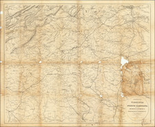
Highly detailed map of North Carolina, published by OW Gray.
The map is colored by counties and showing towns, roads, railroads, lakes, Post Offices, harbors, islands and other details.
Inset map of Beaufort Harbor.
O.W. Gray Biography
O. W. Gray was a publishing firm based in Philadelphia. Later, they published as O. W. Gray & Son. They published atlases in the late nineteenth century. Gray's National Atlas was one of the most successful commercial ventures of the 1870s and one of the last to employ hand coloring on maps.

![[ Cherokee Nation ] A Map of the Tennassee Government formerly Part of North Carolina from the latest Surveys. 1795.](https://storage.googleapis.com/raremaps/img/small/100899.jpg)
![[ Virginia, Carolinas, Georgia ] Carte De la Virginie . . .](https://storage.googleapis.com/raremaps/img/small/41731.jpg)