|
||

|

|
|

|
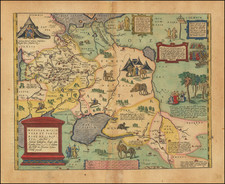
Scarce early-19th-century map of Siebenburgen (Seven Castles) also known as Transylvania. The map was produced by Tranquillo Mollo, the leading map publisher in Vienna at the beginning of the 19th century.
The key elaborates the map's coverage of the region, listing various geographic regions and settlements within Siebenbürgen (Transylvania), a historical region located in central and northwest Romania. The text is presented in a German script, indicative of the multi-ethnic composition of the region, particularly reflecting the significant presence of German-speaking communities, known as Transylvanian Saxons.
The entries are categorized under specific headings that seem to denote different administrative or ethnic regions within Transylvania, such as "Land der Ungarn" (Land of the Hungarians), "Land der Szekler" (Land of the Székelys), and "Land der Sachsen" (Land of the Saxons). Each category lists several places, likely representing counties, towns, or jurisdictions within these larger areas.

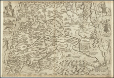
![[Crimea / Ukraine Battle Map ] Charte der Kriegs Operationen am Donn und Dniepr Ihro Russisch Key Serl: Maiest: Glorieusen Armeen A: 1736 gestorchen bey der keyserl: Acad: der Wissensch: in St. Petersb.](https://storage.googleapis.com/raremaps/img/small/101811.jpg)
![[ Prague & Egra ] Praga, Bohemiae Metropolis Accuratissime Expressa [with] Egra urbs a Flumio . . .](https://storage.googleapis.com/raremaps/img/small/96919.jpg)