|
||

|

|
|

|
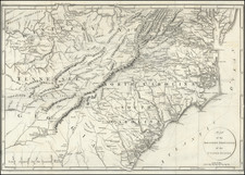
Early Civil War "Seat of War" Birdseye View
Rare separately published view of the are centered on Washington, D.C. and the Potomac River, issued during the American Civil War.
Oriented with the south at the top, the view extends to the mouth of the Chesapeake and beyond, giving a topographical overview of the region, with emphasis on the waterways, major towns and railways. Issued from the perspective of a northern viewer, the map illustrates the region at the outset of the American Civil War, one of the earliest printed views to show this perspective.
This magnificent bird's eye view captures the Virginia-Maryland theater of the American Civil War (1861-1865) from a panoptic perspective, taken shortly before the actual hostilities had commenced.
The view embraces most of Chesapeake Bay, Central Maryland, Eastern Virginia and the District of Columbia and looks dead southward from a stratospheric vantage point just to the south of the Mason-Dixon Line. The means by which the Chesapeake and its tributaries, the James, York, Rappahannock and Potomac rivers are conveyed, creates the visual effect of drawing the viewer into the scene. Washington, D.C. is located almost at the center, while further south is the Confederate capital of Richmond, the key city of Petersburg and near the mouth of the Chesapeake, the great naval ports of Newport and Portsmouth. In the lower left corner is the major commercial port of Baltimore, with Fort McHenry (where the 'Star-Spangled Banner' was composed in 1814) and in the lower right corner is the town of Harper's Ferry, Virginia.
This magnificent view was likely made in the late spring of 1861, after the Civil War had commenced but before the conflict had entered the Virginia-Maryland theater in earnest. The Confederate States of America were officially constituted on February 4, 1861. From that point onwards, war had been universally anticipated, although nobody was sure where the first shots would be fired.
The suspense was lifted upon the Battle of Fort Sumter in Charleston Harbor, South Carolina, on April 12-14, 1861. Following that event, an uneasy situation developed. The Confederates prepared for a defensive conflict, while the Union Army, with its vast numerical and technological superiority vacillated and it was many weeks before major battle was joined. Indeed, many on the Northern side were initially complacent, assuming that the Union would effortlessly crush the rebels whenever the occasion arose.
As it was widely viewed that major battles would be joined somewhere in between the Union and Confederate capitals, Prang sought to anticipate events. In fact, the region had already seen some conflict related to the war. On October 16, 1859, in Harper's Ferry, In Virginia (which would become a part of West Virginia in 1863), the radical abolitionist John Brown seized the United States Army arsenal in an effort to acquire arms to support a hoped-for slave rebellion against the South. Brown's efforts were quickly brought down, however, the raid on Harper's Ferry presaged the bloodshed that was to come.
While the view shows the roads, railways and valleys that would soon facilitate military movement, it features no battle information. The war in the region began in earnest later on, with the First Battle of Bull Run (or the First Battle of Manassas) on July 21, 1861. Shortly before the opposing armies met in Prince William County, Virginia, just outside of Washington, Union dignitaries prepared picnics on an overlooking ridge, where they eagerly expected to watch the Union Army decimate the Confederate forces. However, events did not transpire as planned, as the Southerners quickly broke the Union lines, sending the Northern army (and the spectators) in a headlong retreat.
While the Union eventually seized the areas of northernmost Virginia near the Potomac, the Confederates also won the Second Battle of Bull Run, fought on August 28-30, 1862. The conflict then proceeded to Sharpsville, Maryland, located just off of the view, where the Battle of Antietam was fought on September 17, 1862. This epic altercation, which involved 113,000 troops, resulted in a technical draw but a strategic Union victory, as the Southerners were prevented from continuing their planned invasion of the North.
The theater depicted on the view also featured the final showdown of the war, the Richmond-Petersburg Campaign, by which after a long siege lasting from June 1864 to March 1865, the Union seized the Confederate capital of Richmond. The war was ended soon thereafter with the Confederacy's complete surrender on April 9, 1865, at Appomattox Court House, Virginia.
The view is very similar to John Bachmann's first seat of war view, although Bachmann would quickly switch formats to his Panorama of the Seat of War. Birds eye view of Virginia, Maryland, Delaware, and the District of Columbia (issued from 1861 to 1864). This view captured the region from an easterly perspective and ran into four states, being updated with the locations of battles (marked by crossed-swords). The various states of this view were each printed in far greater numbers than Bachmann's present earlier view.
Rarity
The view is very rare.
OCLC locates examples at Massachusetts Historical Society, University of Michigan (Clements Library) and British Library.
We were unable to locate any examples on RBH or AMPR.
![[ District of Columia ] Carte Geographique, Statistique et Historique Du District De Colombie](https://storage.googleapis.com/raremaps/img/small/84686.jpg)