This item has been sold, but you can enter your email address to be notified if another example becomes available.


|
||

|

|
|

|
Stock# 10286
Description
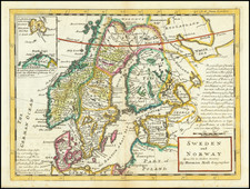
Detailed regional map of Scandinavia, the Baltic Sea and the Gulf of Bothnia, with a small inset Sketch Map Shwing the Relative Positions and Climate of Norway. Showns towns, railroads, rivers, lakes, bays, islands, etc. Adam & Charles Black were among the leading publishers of atlases and travel books in the 19th Century England.
![Europe No. 16. Partie De La Russie D'Europe [Tambow, Woroniege, Saratow and Territoire De La Milice De Don, etc.]](https://storage.googleapis.com/raremaps/img/small/19823.jpg)