


|
||

|

|
|

|
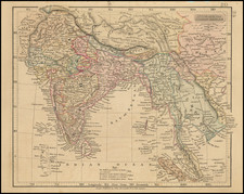
This large-format 1828 map by John Walker, delineating Southeast Asia from China to Singapore and from the Gulf of Martaban to Vietnam and Hainan, stands as a landmark in cartographic history.
Walker's map is the first accurate depiction of the Siamese coastlines, incorporating European and clandestinely acquired Siamese surveys. The map’s genesis lies in the strategic and largely insular nature of early 19th-century Siam, a land then veiled from European trade and diplomacy, rendering the map not only a piece of geographical representation but also a document of geopolitical intrigue and colonial aspirations.
The backdrop of this cartographic creation is the shifting geopolitical landscape of Southeast Asia following the Burmese-Siamese War (1765-1767). Post-war, Siam emerged as a dominant power, engaging in territorial expansions and resisting the colonial influences that ensnared neighboring states. This period saw British colonial advances in Burma and the Malay States, positioning Siam as a singular entity of full sovereignty amidst a region under increasing European sway.
The impetus for the map’s creation was the diplomatic mission led by John Crawfurd, dispatched by the British to assess and engage with the Siamese kingdom. Despite the mission’s limited success in terms of diplomatic achievements, it resulted in the acquisition of significant cartographic information, particularly of Siam. This included surveys and data surreptitiously shared by local navigators, offering unprecedented insights into regions previously obscured from European knowledge. The amalgamation of these sources by John Walker underpins the map's historical and geographical significance.
A noteworthy aspect of the map is its portrayal of a wall in Vietnam, a feature derived from outdated sources and reflecting the limitations and misunderstandings inherent in early cartographic efforts.
The publication history of this map to illustrates John Crawfurd’s journal, underscores its importance in the annals of British exploration and colonial administration.
![Tabula Asiae XI [Southeast Asia]](https://storage.googleapis.com/raremaps/img/small/95794.jpg)

![(Spice Islands) [Banda, Goonog Appee or Burning Mountain, and Banda Neira]](https://storage.googleapis.com/raremaps/img/small/94740.jpg)