|
||

|

|
|

|
Stock# 102784
Description
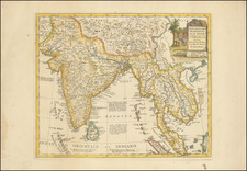
Striking and highly detailed map of the region from Sumatra and Malaca and Southern China to the Philippines, New Guinea and Northern Australia, centered on Borneo.
Includes a large inset of the Marianas.
Wonderful early detail, derived from the Neptune Orientale, published by the French Hydrographical Department in the mid-18th century.
Condition Description
Engraving on 18th-century laid paper. Original hand-color in outline. Minor centerfold toning.
Reference
Pedley, Bel et Utile, #413.
Paolo Santini Biography
Paolo Santini (1729-1793) was an Venetian engraver known especially for his religious prints and fine cartographic engravings. He published in Venice and may have a been a member of the clergy. In his maps, he largely adopted and adapted the work of his French counterparts, especially the brothers de Vaugondy.
![Chart of the West Coast of Sumatra, From Bencoolen to Key Sers Bay [with:] Plan of Cawoor Bay [and:] Plan of Pulo Pisang [and:] Plan of Little Fortune Island and Billimbing Bay](https://storage.googleapis.com/raremaps/img/small/94362.jpg)