|
||

|

|
|

|
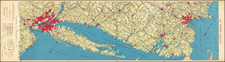
Interesting antique printed color map and tourist brochure combination focusing on Martha's Vineyard, Nantucket, and their vicinities, produced circa 1910 by The Matthews-Northrup Works for the New York, New Haven, and Hartford Railroad.
The map delineates the geographic span from New Bedford to Monomoy, including the Elizabeth Islands and parts of Cape Cod, from Woods Hole to Osterville. It meticulously details steamboat and railroad routes, serving as a navigational aid and promoting the accessibility of the region. This emphasis on transportation routes reflects the era's burgeoning travel industry and the railroad's role in facilitating leisure travel to these idyllic islands.
The accompanying tourist booklet serves to complement the map with printed photographs, evocative illustrations, and visitor information, enriching the potential traveler's perspective. The visual and textual content is designed to entice and inform, painting a picture of an idyllic getaway steeped in natural beauty and leisurely pursuits.

![[Cape Cod area / Nantucket / Martha's Vineyard / Boston Bay]. (Revolutionary War Era Manuscript Sea Chart)](https://storage.googleapis.com/raremaps/img/small/69611.jpg)