|
||

|

|
|

|
Rare California Pictorial / Poster Map
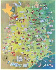
This 1976 poster map presents a whimsical and colorful portrayal of the state of California, highlighting its diverse geography, culture, landmarks, and popular stereotypes associated with different regions.
Created in a playful and cartoonish style, the map is part of the "Funny Funny World" series, designed not only to amuse but also to inform viewers about the unique aspects of California life and geography.
The illustration covers the entirety of California, from the northern forests and mountains near the Oregon border down to the sunny beaches and deserts bordering Mexico. Major cities and regions, such as San Francisco, Los Angeles, and San Diego, are prominently featured, each represented by iconic symbols and humorous caricatures that reflect their cultural significance and popular perceptions.
San Francisco is depicted with symbols such as the Golden Gate Bridge and whimsical characters, suggesting its artistic vibe and historical importance. Southern California, particularly Los Angeles, is filled with references to the entertainment industry, surf culture, and beach life. The central valley and desert areas highlight agricultural significance and desert landscapes, respectively, portraying a variety of activities and industries such as winemaking and outdoor adventures.
This map captures the spirit of the 1970s, a period marked by vibrant counterculture movements and significant social change. It reflects the era's playful and irreverent attitude toward state identities and regional stereotypes. The exaggerated features and comical elements are intended to entertain while providing insight into the state's geography and cultural landmarks.