


|
||

|

|
|

|
Stock# 102767
Description
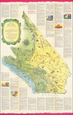
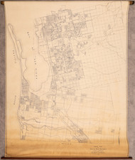
Interesting early pictorial map of San Diego County (with a map of the downtown, La Jolla, and Balboa Park areas on the verso), published by the San Diego-California Club.
The downtown-area map on the verso shows several unusual features, including an ice rink in National City, the "Airway Radio Beacon" in Mission Bay, the Rosecroft Begonia Gardens on Point Loma, and fish markets on the waterfront south of Market Street. An inset shows Balboa Park and the "Zoological Gardens" in great detail.
The county map is equally interesting, spanning the coastline from Tijuana to San Onofre, and reaching inland as far as Anza-Borrego, and it also includes numerous pictorial images.
Condition Description
Color folding map on 20th-century wove paper. Printed on both sides. Very minor loss in bottom righthand side on fold, as shown.
![[Premier Hotels in Swizterland] Hotels de tout Premier Rang de Suisse](https://storage.googleapis.com/raremaps/img/small/87442.jpg)
![Camp Pendleton [cover:] Two Weeks With The Marines in California](https://storage.googleapis.com/raremaps/img/small/92525.jpg)
![(San Diego Photograph) 225. San Diego Mission. Oldest in the State. Established 1769 [Original boudoir card format albumen photograph of San Diego Mission and St. Anthony's Indian School Girl's Dormitory]](https://storage.googleapis.com/raremaps/img/small/92622.jpg)
![(San Diego) [Manuscript letter by a young woman concerning Alonso Horton and Economic Conditions in San Diego, dated Dec. 4, 1877]](https://storage.googleapis.com/raremaps/img/small/97845.jpg)