


|
||

|

|
|

|
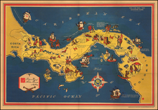
Utopian Town Plan for a Panama Canal Colony in 1860
This fantastical town plan was the brainchild of Athanase Airiau, a utopian colonization scheme in Central America connected to his proposal for an interoceanic canal through the Isthmus of Darien, now known as the Isthmus of Panama.
The Airiau canal plan was a full 50 years before the actual completion of the Panama Canal in 1914. This beautifully hand-colored octagonal plan shows a carefully organized, seemingly self-sufficient community, centered around a church - Eglise de Notre Dame de France. The grand Agricultural City has roads that zig and zag without any particular purpose beyond top-down aesthetics, with some roads changing course in the middle of open fields where a straight line would have sufficed. Airiau's vision brings to mind similar geometrically complex colonial plans from previous centuries, especially Sir Robert Montgomery's 1717 plan for the Margravate of Azilia - envisioned as a "future Eden" to be established on lands south of the Savannah River.
Airiau aimed his proposal at the authorities of the Granadine Confederation, present-day Colombia. His vision was centered around the canalization and colonization of the Isthmus of Panama. Airiau's ambitious plan included founding 150 farms and a city to be populated by European settlers, who would engage in agricultural activities as well as contribute to the construction and maintenance of the proposed canal. As shown in the present elaborate town plan, Airiau was not merely proposing an infrastructural endeavor but a fully utopian scheme for colonization, featuring pre-defined sections for diverse crops such as vanilla, nopal, indigo, tobacco, cereals, cocoa, cotton, vineyards, sugar, sorghum, fruits, and vegetables, along with various types of livestock.
A selection of notable details from the plan:
- Champ de Tabac et des Cereales
- Parc de Genisses de la race Bovine
- Champ des Nopaleries
- Champ de Cannes a sucre et de sorgho
- Prairie des Cafeiers
- Prairie des Vignes
- Champ de Cacoyers
An extensive text describes the basic idea behind the colony: free passage for settlers and their families, a commitment of twenty years, a family council to maintain order and harmony. Settlers' share to be 25% of the net profits of the colony.
The map is dedicated to a notable political figure of the time, Pedro Alcántara Herrán, styled within an allegorial cartouche as "Ex Presidente de la Nouvelle Grenade et Ministre Plenipotentiaire de la Confederacion Grenadine."
Airiau published this map in a publication outlining his dual-purpose, canal/colonization plan: Canal Interocéanique par L'Isthme du Darien, Nouvelle-Grenade (Amérique du Sud) Canalisation par la Colonisation (Paris, 1860). His report appeared during a period of significant interest in and debate over the potential construction of a canal that would connect the Atlantic and Pacific Oceans and thereby revolutionize global trade routes and maritime navigation. Airiau's advocacy for the Darien route over others is grounded in a comprehensive analysis of the region's geography, climate, and natural resources, positing it as the most favorable location for the canal's construction and for the establishment of a European colony.
Despite the innovative nature of Airiau's proposal, it did not come to fruition, attributed to its utopian character. Nonetheless, this historical episode illustrates the early and ambitious endeavors to improve global maritime routes and the development of the Panama region long before the successful completion of the Panama Canal in the 20th century.
Rarity
This unusual town plan is very rare in the market.
Athanase Airiau, a member of the Paris "Society for a Canal Interocéanique," made a fascinating contribution in the mid-19th century towards the conceptualization of a canal through the Panamanian isthmus.
In 1860, Airiau articulated a vision for France's leadership in this monumental engineering endeavor, asserting, "It is to France that belongs the initiative to establish a canal." He further justified this claim by appealing to the national character of France, suggesting that such an exploration would align with "the aptitudes and penchants of our nation, to the allure of our generous policies, our humanitarian tendencies around which one can rally, yet which are no less eminently honorable."
Airiau also addressed the geopolitical implications of the canal in a letter to the French government, emphasizing the need to counteract American expansionism as articulated through the Monroe Doctrine. He argued for a French colonial presence in Panama to "preserve South America from the invasion of the Monroe Doctrine which dreams despotically of Latin submission to its profit, to the detriment of our Old Europe."
His book on the French interoceanic canal route, subtitled "canalization for colonization," included detailed maps and diagrams to illustrate the proposed canal route. One main map showed a direct, sea-level canal from Caledonia on the Caribbean coast to just north of the Lara River, indicating a passage through the San Blas Mountains of the continental divide. The publication included profile diagrams comparing this route favorably against other proposed routes in Panama, Nicaragua, and Mexico, highlighting its feasibility and advantages.
Airiau's maps also featured a new city, marked by a maroon octagon along the canal route, indicating plans for urban development as part of the canal project. This depiction, alongside views of sailing vessels navigating the proposed canal, underscored the comprehensive nature of Airiau's vision for the canal's role in global commerce and regional development.
Airiau's concepts have drawn relatively little note in modern times, although in one case, the author's opinions were quite colorful. Omar Jaén Suárez comments:
In 1860, French merchant Athanase Airiau published a book with an absolutely delusional drawing. A geometrical utopia laid out as a large octagonal city in the center of the Chucunaque basin, transformed into an immense French-style garden with livestock and cut in two, exactly in its center, by a canal at sea level that would join the Atlantic and the Pacific in a straight line, crossing the San Blas mountain range to the north.
While the project never came to fruition, its grand illustrations are indeed remarkable.
![Amer. Sep. No. 71. Partie Du Mexique et de Guatemala [Oaxaca, Tabasco, Chiapa, Verapaz]](https://storage.googleapis.com/raremaps/img/small/96583.jpg)
![[Caribbean]](https://storage.googleapis.com/raremaps/img/small/85443.jpg)