


|
||

|

|
|

|
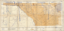
This early 20th-century map offers a detailed depiction of Pecos County, Texas, emphasizing the extensive oil and gas industry presence within the region.
The map differentiates the leased lands operated by major companies such as Pure Oil, Dixie Oil, Humble Oil, Texas Oils, and Sun Oil through varied color codings, offering an insightful visual representation of the corporate landscape in oil exploration and production during this period. Furthermore, it identifies available acreage for lease.
The map’s utility is heightened by its inclusion of various symbols to denote the locations and statuses of drilling wells, producing wells, and gas wells, offering a comprehensive overview of the area's resource extraction activities.
The cartographic presentation of this map, with its systematic grid overlay and geographical markers, situates the oil fields within the broader topography and infrastructure of Pecos County, including its boundaries, waterways, and roads.
The petroleum industry in Pecos County, located within the Permian Basin, began around 1900 with the drilling of the Turney well, near an ancient oil seep used for lubrication and medicinal purposes. The area's oil potential was highlighted in 1921 by the discovery of the "Miracle Well," leading to the establishment of the Yates oil field in 1926, a significant development in the county's history.
By this period, the Yates, Fort Stockton, and other fields in Pecos County had produced over 710 million barrels of oil. Although natural gas was known to exist in the region, it was initially regarded as an unwanted by-product of oil production. Commercial utilization of natural gas began only after 1925, following its accidental discovery by workers drilling a water well. This marked the start of gas exploitation alongside oil extraction in the county.
![[Dallas / Kennedy Assassination] La Mappa Dell'Odio](https://storage.googleapis.com/raremaps/img/small/89006.jpg)

![Carte De La Louisiane Et Du Cours Du Mississipi . . . Juin 1718 [1st State!]](https://storage.googleapis.com/raremaps/img/small/59797.jpg)