|
||

|

|
|

|
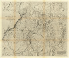
Mexico City to Santa Fe -- El Camino Real de Tierra Adentro -- The Silver Route
Detailed mapping of the "royal road" from Mexico City to Santa Fe, New Mexico, documents northernmost of the four royal roads to Spain's colonial outposts in the New World. First established in 1598, it was also the first trade route in what would become the modern United States.
The map appeared in Humboldt's Atlas Geographique Et Physique Du Royaume De La Nouvelle-Espagne, Fonde Sur Des Observations Astronomiques, Des Mesures Trigonometriques Et Des Nivellemens Barometriques, which was issued as early as 1808 in Berlin.
The map meticulously charts the course along El Camino Real de Tierra Adentro, a crucial artery for commerce and communication within the Spanish colonial domain, at a time when Spain enforced a stringent trade monopoly in its American territories.
Humboldt's map is distinguished by its detailed depiction of the El Camino Real, delineating towns, elevaations, missions, military outposts, and other details along the route. This precision in representation was achieved through Humboldt's reliance on his own astronomical observations for latitude and longitude, combined with the historical accounts from the journals of Don Pedro de Rivera.
The route, captured in three strip-style maps, served as the sole official trade corridor between the viceroyalty's capital and its northern frontier until the 1820s, when American traders began to forge new paths such as the Santa Fe Trail. This period, prior to the opening of new trade routes by American interests, highlights the strategic importance of El Camino Real de Tierra Adentro for the Spanish colonial economy and military presence in the region.
![(Western Photographs) [Collection of 35 Albumen Photographs by Isaiah Taber, Norman Reed, W.H. Jackson and others: California, Arizona, New Mexico, Colorado]](https://storage.googleapis.com/raremaps/img/small/90506.jpg)