|
||

|

|
|

|
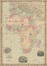
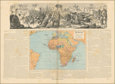
Africa Natural Vegetation Map from Philips' Series of Comparative Wall Atlases
The map depicts the diverse vegetation zones of the African continent, categorizing the flora into distinct ecological types, such as forest, grass, steppe, and desert vegetation. The map employs a color-coded system to differentiate between these types, providing a clear visual representation of the continent's natural botanical distribution.
Historically, this map serves as a document of Africa's ecological conditions prior to significant anthropogenic alterations. It offers a baseline for understanding the natural environment that has shaped human history, agriculture, and biological diversity across Africa. The inclusion of various vegetation types highlights the ecological variety and climatic zones present before the extensive modern changes, making it a valuable resource for historical and environmental research.
The legend, crucial for interpreting the map's content, classifies the vegetation into detailed categories such as Tropical Rain Forest, Savanna, and Desert. This classification aids in the academic analysis of Africa's environmental zones, contributing to a comprehensive understanding of the continent's ecological dynamics.
The map's academic value lies in its detailed representation of Africa's vegetation patterns, reflecting the intricate interactions between climate, topography, and plant life. It serves as a resource for educators, students, and researchers interested in geography, environmental science, and African studies.
![[ Air Travel Routes in Africa ] Ministre de l'air regie Air Afrique](https://storage.googleapis.com/raremaps/img/small/89402.jpg)