


|
||

|

|
|

|
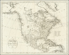
On The Eve of Lewis & Clark and the War of 1812
Rare map of North America, illustrating the Transmississippi West immediately prior to the dissemination of Lewis & Clark's first reports from their expedition to the Pacific Ocean.
The lands acquired by the US in the Louisiana Purchase, extending to the Pacific, are clearly delineated, as is Spain's control of East and West Florida.
The map presents illustrates the hydographical featues of the Upper Missouri River as known to the Americans and English immediately prior to the dissemination of the full Lewis & Clark report, although the Lewis River in Oregon Territory makes clear that some knowledge has been disseminated. Relatively little is known about the Rivers of Oregon Territory.
Further South, California and the Great Basin are still largely unexplored and mythically shown, pre-dating the first appearance of the Rio San Felipe draining from Lakes Timpanagos and still unnamed Lake Teguayo to San Francisco Bay. Similarly, the jumbled set of mountains shown east of the Coastal Range has not yet appeared, although in Southern California, the unnamed mythical (River des Martyres in later editions) flows parallel to the Colorado River.
The limited British explorations in the Arctic Sea is in evidence, pre-dating the explorations of Franklin and Parry over the next 2 decades.

![[First State of the Popple Key Sheet] A Map of the British Empire in America with the French and Spanish Settlements adjacent thereto by Hen. Popple.](https://storage.googleapis.com/raremaps/img/small/92714.jpg)