|
||

|

|
|

|
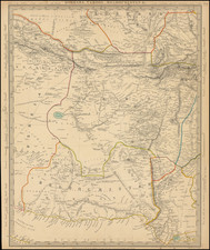
Detailed map of Ancient Persia and environs.
The map delineates the geographical expanse surrounding the Hyrcanian Sea (the ancient name for the Caspian Sea), the Oxus River (now known as the Amu Darya), and the Indus River, presenting a vivid tableau of the ancient world's complex terrains and their interconnected civilizations. Crafted in an era when cartography was as much an art as a science, this map offers a window into the understanding of geography and the significance of these regions in the context of historical trade routes, cultural exchanges, and imperial conquests.
The Hyrcanian Sea, today's Caspian Sea, was a critical body of water in ancient times, acting as a natural boundary for the empires that flourished on its shores and as a vital conduit for trade and communication between the East and West. This sea was surrounded by diverse ecosystems and cultures, contributing to the rich tapestry of ancient civilizations in the region. The map's depiction of the Hyrcanian Sea not only highlights its geographical importance but also its role in the Silk Road and other trade networks that linked the ancient worlds of Rome, Persia, and the steppes of Central Asia.
The Oxus River, or the Amu Darya, has historically been one of the major rivers of Central Asia, forming part of the boundary between the civilizations of the Iranian plateau and the nomadic steppes to the north. The river's course, flowing from the Pamir Mountains through the arid landscapes of today's Afghanistan and Turkmenistan into the Aral Sea, was a crucial artery for the movement of peoples, goods, and ideas. The Oxus not only served as a geographical marker but also as a cultural and economic bridge, facilitating the spread of religions, languages, and technologies across continents.
The Indus River, flowing through the heart of the Indian subcontinent, has been the cradle of civilizations since ancient times. Its fertile plains supported the growth of the Indus Valley Civilization, one of the world's earliest urban cultures. The river's depiction on the map underscores its importance in sustaining life, fostering agricultural advancements, and facilitating trade and communication. The Indus Valley was a hub of cultural and economic exchange, connecting the ancient worlds of India, the Middle East, and Central Asia.
The Arrowsmiths were a cartographic dynasty which operated from the late-eighteenth century to the mid-nineteenth. The family business was founded by Aaron Arrowsmith (1750-1823), who was renowned for carefully prepared and meticulously updated maps, globes, and charts. He created many maps that covered multiple sheets and which were massive in total size. His spare yet exacting style was recognized around the world and mapmakers from other countries, especially the young country of the United States, sought his maps and charts as exemplars for their own work.
Aaron Arrowsmith was born in County Durham in 1750. He came to London for work around 1770, where he found employment as a surveyor for the city’s mapmakers. By 1790, he had set up his own shop which specialized in general charts. Arrowsmith had five premises in his career, most of which were located on or near Soho Square, a neighborhood the led him to rub shoulders with the likes of Joseph Banks, the naturalist, and Matthew Flinders, the hydrographer.
Through his business ties and employment at the Hydrographic Office, Arrowsmith made other important relationships with Alexander Dalrymple, the Hudson’s Bay Company, and others entities. In 1810 he became Hydrographer to the Prince of Wales and, in 1820, Hydrographer to the King.
Aaron Arrowsmith died in 1823, whereby the business and title of Hydrographer to the King passed to his sons, Aaron and Samuel, and, later, his nephew, John. Aaron Jr. (1802-1854) was a founder member of the Royal Geographical Society (RGS) and left the family business in 1832; instead, he enrolled at Oxford to study to become a minister. Samuel (1805-1839) joined Aaron as a partner in the business and they traded together until Aaron left for the ministry. Samuel died at age 34 in 1839; his brother presided over his funeral. The remaining stock and copper plates were bought at auction by John Arrowsmith, their cousin.
John (1790-1873) operated his own independent business after his uncle, Aaron Arrowsmith Sr., died. After 1839, John moved into the Soho premises of his uncle and cousins. John enjoyed considerable recognition in the geography and exploration community. Like Aaron Jr., John was a founder member of the RGS and would serve as its unofficial cartographer for 43 years. Several geographical features in Australia and Canada are named after him. He carried the title Hydrographer to Queen Victoria. He died in 1873 and the majority of his stock was eventually bought by Edward Stanford, who co-founded Stanford’s map shop, which is still open in Covent Garden, London today.
![[India & Central Asia] Tabula Asiae VIII](https://storage.googleapis.com/raremaps/img/small/84897.jpg)
![Il Disegno Della Terza Parte Dell' Asia [Gastaldi's Wall Map of SE Asia with extra panels!]](https://storage.googleapis.com/raremaps/img/small/30554hbp.jpg)
![[Armenia] Pianta dell'Armenia Secondo il Tratto di Berlino](https://storage.googleapis.com/raremaps/img/small/90949.jpg)