


|
||

|

|
|

|
Stock# 102019
Description
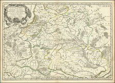
Southern Ukraine / Mykolaiv Oblast
Very scarce regional map of the region at the north end of the Black Sea, between the Bug and the Dniestr River, covering the western part of the Mykolaiv Oblast.
Shows rivers, roads, towns, castles, forests, lakes and a host of other details. Quite possibly the most detailed map of this region to appear in an 18th Century Atlas. From Von Reilly's exceedingly scarce Grosser Deutscher Atlas.
Von Reilley & Schraembl led a revival of map making in Vienna in the late 18th Century which included this and several other sought after works.
![[ Poland ] Stati Della Corona Di Polonia Divisa nelle sue Principali Provincie, e Palatinati Da Guglielmo Sansone Geografo del Re Christmo. E di nuovo data in luce da Gio: Giacomo Rossi, in Roma, alla Pace, l'Anno 1678](https://storage.googleapis.com/raremaps/img/small/92116.jpg)
![Polonia Secondo le Osservazioni dell' Accademia di Parigi [Poland, according to the observations of the Paris Academy.]](https://storage.googleapis.com/raremaps/img/small/67787.jpg)