|
||

|

|
|

|
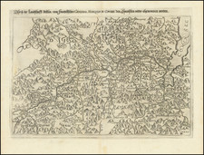
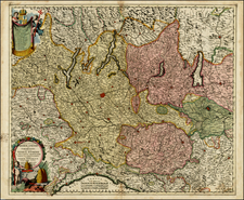
Mapping the Papal States
Finely detailed 3 sheet map of the "State of the Church", published in Venice by Francois Santini, based upon the work of Italian polymath Ruggero Giuseppe Boscovich.
In the 18th century, Ruggero Giuseppe Boscovich, a renowned Jesuit priest, mathematician, and astronomer, produced a detailed map of the State of the Church (Papal States) in Italy. This project, commissioned by the Papal States, aimed to accurately represent the territories under the ecclesiastical jurisdiction of the Papacy, which stretched across much of central Italy, including Rome. Boscovich's work was groundbreaking, utilizing advanced geodetic and astronomical methods to map the region with unprecedented accuracy.
Boscovich’s journey across the varied landscapes of the Papal States involved rigorous scientific methods, including the use of a meridian line in Rome for longitudinal measurements and advanced mathematical techniques to correct geographical distortions. His map was not only a significant scientific achievement but also served as a political statement of the Papal States’ territorial claims during a time when the notion of nation-states was crystallizing in Europe.
Boscovich’s interdisciplinary approach in creating the map marks a milestone in cartography and exemplifies the 18th century's intellectual pursuit of knowledge across different fields.
Paolo Santini (1729-1793) was an Venetian engraver known especially for his religious prints and fine cartographic engravings. He published in Venice and may have a been a member of the clergy. In his maps, he largely adopted and adapted the work of his French counterparts, especially the brothers de Vaugondy.
![[Pozzuoli / Napoli] Explicatio aliquot locorum quae Puteolis spectantur](https://storage.googleapis.com/raremaps/img/small/58733.jpg)