|
||

|

|
|

|
Archive of Walker Clute, Petroleum Geologist, With Geological Reports and Maps of Oil Wells and Oil Rights in California
Interesting archive of maps, photographs and reports of leading Southern California Petrolem Engineer Walker Clute, who was active during the boom times of the California Oil industry and worked for a number of interesting promoters, including Edwin Pauley.
The archive includes 16 reports, about 20 maps, many quite large, showing oil fields mostly in California and, over 30 snapshot photographs of oil operations, c. 1930s or so. A couple of reports are published following Clute’s death, suggesting that this was perhaps the archive of Clute’s firm Hodges and Clute, which continued to operate following his death in 1964. Many reports marked “Office Copy.”
The geologist and value engineer Walker Clute operated out of Los Angeles for several decades, appraising oil rights and authoring reports for various clients. Clute worked for the US Geological Survey, and inaugurated the Oil and Gas division of the California State Research Bureau. He served with the Oil Division of the Los Angeles County Assessor’s Office. He also served as secretary-treasurer for the American Institute of Mining, Metalurgical and Petroleum Engineers.
Clute was active in a period of growth for the California oil industry at a time when the industry was growing and evolving in Southern California and beyond. Offered here is his professional archive, which contains many large maps of the Southern California oil fields, many with Clute’s notations.
. As a group they provide an important primary source on these early California wells, particularly for the inclusion of Clute’s reports, some of which are unrecorded. We find no institutional holdings of Clute’s private practice work or that of his firm specifically, though he did author other papers as parts of geological reports that are held as part his government work. We have prepared a full inventory of the collection below.
Reports
- Allen, R.E. Report on the Oil Possibilities of Australia. Geological Department of King G. Gillette, December 1, 1925. Report in leatherette covers, 17 pp. plus maps and 27 captioned photographs.
- Chase, G.G. Valuation Report. Producing Oil Properties of C.P. Ritter in the Huntington Beach Oil Field California as of August 15, 1933. Costa Mesa, 1933. Report in cardstock covers, 27 pp.
- Clute, Walker. Analytical Appraisal Royalty Interest Owned by the Mrs. Thomas Buck Estate in the Texas Cos. Griswold One Lease, Long Beach Oil Field, California, as of December 20, 1943. Los Angeles, 1944. Report in cardstock portfolio, appx. 15 pp. with maps and folding charts.
- Clute, Walker. Appraisal of Easterly One-Half Petroleum Management Corporation Miller Lease, Huntington Beach Oil Field, Orange County, California, March 25, 1940. Los Angeles, 1940. Report in heavy cardstock covers, 13 pp. plus folding maps and charts.
- Clute, Walker. Evaluation of Certain Royalty Interests Owned by San Gabriel River Improvement Co., Seal Beach Oil Field, California, as of May, 1948. Report in leatherette cover. 20 pp. plus folding charts and maps.
- Clute, Walker. Form O Data. Estimate of Oil Reserves, Union Pacific Royal Company, Wilmington Oil Field. Los Angeles, 1961. report in cardstock folio, 30 pp. plus various unpaginated inserts at rear.
- Clute, Walker. Geology and Oil Possibilities of the Sievers Property Castaic Area, Los Angeles County, California. Los Angeles, 1944. Report in cardstock folio, 20 pp.
- Clute, Walker. Report on San Gabriel River Improvement Co. Lease, Seal Beach Oil Field, January 1, 1941. Los Angeles, 1941. Report in heavy cardstock covers, March 14, 1941.
- Clute, Walker. Report on the Bishop-Signal Properties, Mount Poso Area, Calif., March 15, 1943. Los Angeles, 1943. Report in heavy cardstock folio, 26 pp.
- Clute, Walker. Valuation of ⅙ Royalty Interest in Barnsdall OPil Company’s O’Dea Lease. Los Angeles, 1944. Report in cardstock folio, 8 pp. plus various folding maps and charts.
- Clute, Walker. Valuation of Lessee Interest Held By Consolidated Petroleum in the Garret-Maloy and Barham Leases Signal Hill Oil Field, California, as of June 1, 1948. Los Angeles, 1948. Report in heavy cardstock covers, 10 pp. plus maps and charts.
- Clute, Walker. Valuation of Oil and Gas Interests Held by Consolidated Petroleum Corporation as of June 1, 1942. Los Angeles, 1942. Report in heavy cardstock covers, 10 pp. plus folding plates and maps.
- Clute, Walker. Valuation of One Percent Royalty Interests in the Braille and Warren Leases, Newhall Area, As of Nov. 5., 1948. Los Angeles, 1948. Report in heavy cardstock covers, appx. 15 pages including folding maps, unpaginated.
- Clute, Walker. Valuation of Well “CY-2” of Los Angeles Basin Drilling Co., Wilmington, Calif., as of February 1, 1946. Los Angeles, 1946. Report in heavy cardstock folio, 12 pp. plus folding charts and maps at rear.
- Clute, Walker. [Hodges and Clute Firm] Form O Data, Estimate of Oil Reserves, Union Pacific Railroad Company, Wilmington Oil Field, California, as of December 31, 1968. Los Angeles, 1969?, report in heavy cardstock folio. 17 pp. plus various charts at rear.
- Wents, Jr., John, et al. Geological Report and Appraisal on Certain Lands in Contra Costa County, Califonria. US Case No. 23529-G. Los Angeles, 1945. Report in leatherette portfolio, 60 pp. plus photographs and folding maps.
Maps
- Cross Section along Line F-F (Plate 1)...Huntington Beach Oil Field, Orange County, California. California State Mining Bureau. 31 x 21 inches.
- Cross-Section Along D-D (Plate 1) Producing Formations and Existing Water Conditions, Huntington Beach Oil Field. California State Mining Bureau, 1923. 48 x 28 inches.
- Ecklund, C.A. [Topographical Map of Glendale], 40 x 16 inches, c. 1930.
- Ed. W. Pauley. Assessment Map, Lawndale. Office Copy for a project in Lawndale. Very large map. 43 x 61 inches.
- Inglewood District, Los Angeles Co., Cal. 25 x 21 inches. Undated.
- Inglewood Field, Structural Contour Map. NP, 1928. 18 x 18 inches.
- Map of Devil’s Den Oil Field Kern Co., Cal. Department of Natural Resources. 35 x 18 inches.
- Map of Elk Hills Oil Field Kern County, Calif. California State Mining Bureau, c. 1930. 40 x 26 inches.
- Map of Huntington Beach Oil Field, Orange County, Cal. Department of Natural Resources, 1920. 46 x 36 inches.
- Map of Inglewood Oil Field, Los Angeles, California. Ca. Division of Mines and Mining, 1929. 37 x 36 inches.
- Map of Long Beach Oil Field, Los Angeles Co., California. California State Mining Bureau, 1922. 45 x 28 inches.
- Map of Long Beach Oil Field, Los Angeles, Showing Subsurface Contours Top of Alamitos Zone. California State Mining Burea, 1923. 66 x 24 inches.
- Pauley Petroleum, Inc., SFLI Lease, Lawndale, Facilities Map. W.S. Clute and Son, 1960. 29 x 18 inches.
- Properties of Cargo Oil Company. C. 1930, undated. 25 x 28 inches.
- Reagan, J.W. Map Showing General Location of Dams, Reservoirs and Channels… for Flood Control and Conservation. [Los Angeles Region]. Board of Supervisors, 1924. 21 x 21 inches.
- Signal Hill Oil Field, Long Beach, California. Willis and Collins, 1922. A massive and quite attractive map. 78 x 26 inches.
- Structure and Contour Map. Top of Kettleman Sand. Kettleman Hills Oil Field, Fresno and King’s Counties. Continental Oil Company, 1934. 40 x 44 inches.
- Trembleton, J.R. Composite Transverse Section A-A, North Dome Kettleman Hills. 1932, location unknown. 51 x 30 inches.
Miscellaneous Items:
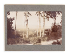
1. Over thirty snapshot photographs of oil operations, c. 1930s or so.
![[California Road Atlas] Easy Fold Maps of California Highways](https://storage.googleapis.com/raremaps/img/small/73977.jpg)
![Gray's New Map of California [Yosemite & San Francisco insets]](https://storage.googleapis.com/raremaps/img/small/89713.jpg)